Piano elevation
Piano (Liguria, Provincia di Savona), Italy elevation is 520 meters and Piano elevation in feet is 1706 ft above sea level [src 1]. Piano is a seat of a third-order administrative division (feature code) with elevation that is 198 meters (650 ft) bigger than average city elevation in Italy.
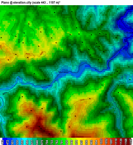
Below is the Elevation map of Piano, which displays elevation range with different colors. Scale of the first map is from 443 to 1197 m (1453 to 3927 ft) with average elevation of 736 meters (=2415 ft) [note 1]
These maps also provides idea of topography and contour of this city, they are displayed at different zoom levels. More info about maps, scale and edge coordinates you can find below images.
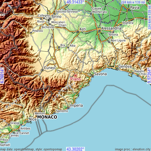
| \ | Map #1 | Topo.Map |
| Scale [m] | 443..1197 m | × |
| Scale [ft] | 1453..3927 ft | × |
| Average | 736 m = 2415 ft | × |
| Width | 6.99 km = 4.3 mi | 223.7 km = 139 mi |
| Height | 6.99 km = 4.3 mi | 223.7 km = 139 mi |
| ↑Max Latitude | 44.348234° | 45.31433° |
| Latitude at center | 44.3168° | 44.3168° |
| ↓Min Latitude | 44.285349° | 43.30202° |
| ← Min Longitude | 8.122445° | 6.76014° |
| Longitude center | 8.16639° | 8.16639° |
| →Max Longitude | 8.210335° | 9.57264° |
Nearby cities:
Cities around Piano sort by population:
• Millesimo elevation 430 m
6.3 km,  27°
27°
• Murialdo 517 m
0.1 km,  84°
84°
• Roccavignale 451 m
5.3 km,  21°
21°
• Valzemola 570 m
5.3 km,  6°
6°
• Bormida 586 m
6.8 km,  129°
129°
• Montezemolo 734 m
7 km,  343°
343°
• Osiglia 669 m
4.8 km,  145°
145°
• Perlo 745 m
6.6 km,  284°
284°
• Castelnuovo di Ceva 740 m
5.1 km,  323°
323°
• Massimino 535 m
7.8 km,  255°
255°
• Cengio Alto 521 m
7.9 km, 18°
• Plodio 471 m
7.6 km,  57°
57°
Multilingual:
 En español:
Piano elevación 520 m.
 En France:
Piano élévation 520 m.


Sources and notes:
- [note 1] Map square and city borders are not equal. Map elevation data is calculated only from area inside that square.
- [src 1] Elevation data from geonames database provided with same terms of usage.
- [src 2] The elevation map of Piano is generated using elevation data from NASA's 3 arcsec (90m) resolution SRTM data.
- [src 3] Base (background) map © OpenStreetMap contributors tiles are generated by Geofabrik and OpenTopoMap.
Copyright & License:
This Piano Elevation Map is licensed under CC BY-SA. You may reuse any part from this page, if you give a proper credit by linking to this URL:
 More info on terms of use page.