Montale elevation
Montale (Tuscany, Provincia di Massa-Carrara), Italy elevation is 237 meters and Montale elevation in feet is 778 ft above sea level [src 1]. Montale is a seat of a third-order administrative division (feature code) with elevation that is 85 meters (279 ft) smaller than average city elevation in Italy.
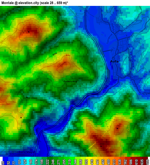
Below is the Elevation map of Montale, which displays elevation range with different colors. Scale of the first map is from 28 to 659 m (92 to 2162 ft) with average elevation of 233.7 meters (=767 ft) [note 1]
These maps also provides idea of topography and contour of this city, they are displayed at different zoom levels. More info about maps, scale and edge coordinates you can find below images.
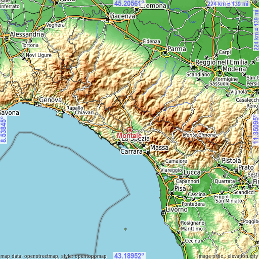
| \ | Map #1 | Topo.Map |
| Scale [m] | 28..659 m | × |
| Scale [ft] | 92..2162 ft | × |
| Average | 233.7 m = 767 ft | × |
| Width | 7.01 km = 4.4 mi | 224.2 km = 139.3 mi |
| Height | 7.01 km = 4.4 mi | 224.2 km = 139.3 mi |
| ↑Max Latitude | 44.237683° | 45.20561° |
| Latitude at center | 44.20619° | 44.20619° |
| ↓Min Latitude | 44.17468° | 43.18952° |
| ← Min Longitude | 9.900755° | 8.53845° |
| Longitude center | 9.9447° | 9.9447° |
| →Max Longitude | 9.988645° | 11.35095° |
Nearby cities:
Cities around Montale sort by population:
• Santo Stefano di Magra elevation 30 m
6.6 km,  195°
195°
• Ceparana-Carpena 30 m
6.6 km,  228°
228°
• Aulla 60 m
2.7 km,  89°
89°
• Albiano Magra 47 m
4.1 km,  213°
213°
• Podenzana 276 m
0.2 km,  271°
271°
• Monti 154 m
6.9 km,  47°
47°
• Terrarossa 84 m
3.3 km,  23°
23°
• Piana Battolla 43 m
7.4 km,  258°
258°
• Pallerone 78 m
4.6 km, 91°
• Barbarasco 112 m
3.9 km,  1°
1°
• Bolano 324 m
4.5 km,  242°
242°
• Tresana 160 m
5.9 km,  334°
334°
Multilingual:
 En español:
Montale elevación 237 m.
 En France:
Montale élévation 237 m.


Sources and notes:
- [note 1] Map square and city borders are not equal. Map elevation data is calculated only from area inside that square.
- [src 1] Elevation data from geonames database provided with same terms of usage.
- [src 2] The elevation map of Montale is generated using elevation data from NASA's 3 arcsec (90m) resolution SRTM data.
- [src 3] Base (background) map © OpenStreetMap contributors tiles are generated by Geofabrik and OpenTopoMap.
Copyright & License:
This Montale Elevation Map is licensed under CC BY-SA. You may reuse any part from this page, if you give a proper credit by linking to this URL:
 More info on terms of use page.