Capriglia elevation
Capriglia (Campania, Provincia di Avellino), Italy elevation is 532 meters and Capriglia elevation in feet is 1745 ft above sea level [src 1]. Capriglia is a seat of a third-order administrative division (feature code) with elevation that is 210 meters (689 ft) bigger than average city elevation in Italy.
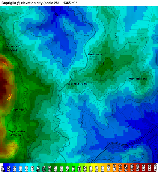
Below is the Elevation map of Capriglia, which displays elevation range with different colors. Scale of the first map is from 281 to 1365 m (922 to 4478 ft) with average elevation of 507.8 meters (=1666 ft) [note 1]
These maps also provides idea of topography and contour of this city, they are displayed at different zoom levels. More info about maps, scale and edge coordinates you can find below images.
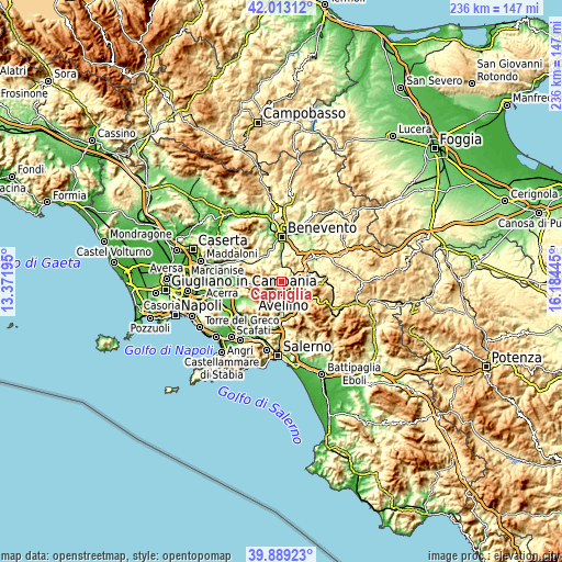
| \ | Map #1 | Topo.Map |
| Scale [m] | 281..1365 m | × |
| Scale [ft] | 922..4478 ft | × |
| Average | 507.8 m = 1666 ft | × |
| Width | 7.38 km = 4.6 mi | 236.2 km = 146.8 mi |
| Height | 7.38 km = 4.6 mi | 236.1 km = 146.7 mi |
| ↑Max Latitude | 40.992898° | 42.01312° |
| Latitude at center | 40.95972° | 40.95972° |
| ↓Min Latitude | 40.926525° | 39.88923° |
| ← Min Longitude | 14.734255° | 13.37195° |
| Longitude center | 14.7782° | 14.7782° |
| →Max Longitude | 14.822145° | 16.18445° |
Nearby cities:
Cities around Capriglia sort by population:
• Avellino elevation 360 m
5.1 km,  167°
167°
• Atripalda 307 m
6.1 km,  137°
137°
• Mercogliano 484 m
5.1 km,  213°
213°
• Altavilla Irpina 354 m
5.2 km,  2°
2°
• Capriglia Irpina 533 m
0.1 km,  309°
309°
• Prata di Principato Ultra 333 m
5.8 km,  59°
59°
• Ospedaletto d'Alpinolo 677 m
3.5 km,  229°
229°
• Manocalzati 439 m
6.2 km,  109°
109°
• Grottolella 571 m
1.6 km,  34°
34°
• Montefredane 594 m
3 km,  89°
89°
• Summonte 717 m
3.1 km,  246°
246°
• Sant'Angelo A Scala 590 m
3.6 km,  297°
297°
Multilingual:
 En español:
Capriglia elevación 532 m.
 En France:
Capriglia élévation 532 m.
 Auf Deutsch:
Capriglia höhe über dem Meeresspiegel ist 532 m.

Sources and notes:
- [note 1] Map square and city borders are not equal. Map elevation data is calculated only from area inside that square.
- [src 1] Elevation data from geonames database provided with same terms of usage.
- [src 2] The elevation map of Capriglia is generated using elevation data from NASA's 3 arcsec (90m) resolution SRTM data.
- [src 3] Base (background) map © OpenStreetMap contributors tiles are generated by Geofabrik and OpenTopoMap.
Copyright & License:
This Capriglia Elevation Map is licensed under CC BY-SA. You may reuse any part from this page, if you give a proper credit by linking to this URL:
 More info on terms of use page.