Agliano elevation
Agliano (Piedmont, Provincia di Asti), Italy elevation is 256 meters and Agliano elevation in feet is 840 ft above sea level [src 1]. Agliano is a seat of a third-order administrative division (feature code) with elevation that is 66 meters (217 ft) smaller than average city elevation in Italy.
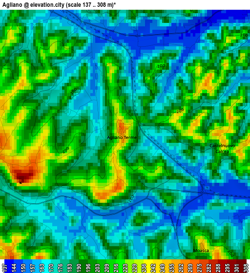
Below is the Elevation map of Agliano, which displays elevation range with different colors. Scale of the first map is from 137 to 308 m (449 to 1010 ft) with average elevation of 188.1 meters (=617 ft) [note 1]
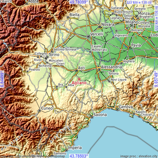
These maps also provides idea of topography and contour of this city, they are displayed at different zoom levels. More info about maps, scale and edge coordinates you can find below images.
| \ | Map #1 | Topo.Map |
| Scale [m] | 137..308 m | × |
| Scale [ft] | 449..1010 ft | × |
| Average | 188.1 m = 617 ft | × |
| Width | 6.94 km = 4.3 mi | 221.9 km = 137.9 mi |
| Height | 6.94 km = 4.3 mi | 221.9 km = 137.9 mi |
| ↑Max Latitude | 44.822818° | 45.78099° |
| Latitude at center | 44.79164° | 44.79164° |
| ↓Min Latitude | 44.760445° | 43.78503° |
| ← Min Longitude | 8.207295° | 6.84499° |
| Longitude center | 8.25124° | 8.25124° |
| →Max Longitude | 8.295185° | 9.65749° |
Nearby cities:
Cities around Agliano sort by population:
• Costigliole d'Asti elevation 238 m
5.4 km,  262°
262°
• Agliano Terme 252 m
0.2 km,  202°
202°
• Mombercelli 189 m
4.5 km,  49°
49°
• Montegrosso 172 m
3.4 km,  341°
341°
• Vinchio 235 m
5.9 km,  68°
68°
• Montaldo Scarampi 271 m
4.3 km,  8°
8°
• Castelnuovo Calcea 226 m
2.7 km,  101°
101°
• Vigliano d'Asti 245 m
5 km, 339°
• Calosso 390 m
6.1 km, 198°
• San Marzano Oliveto 289 m
5.4 km,  139°
139°
• Vaglio Serra 271 m
6.9 km,  85°
85°
• Moasca 250 m
3.8 km,  145°
145°
Multilingual:
 En español:
Agliano elevación 256 m.
 En France:
Agliano élévation 256 m.


Sources and notes:
- [note 1] Map square and city borders are not equal. Map elevation data is calculated only from area inside that square.
- [src 1] Elevation data from geonames database provided with same terms of usage.
- [src 2] The elevation map of Agliano is generated using elevation data from NASA's 3 arcsec (90m) resolution SRTM data.
- [src 3] Base (background) map © OpenStreetMap contributors tiles are generated by Geofabrik and OpenTopoMap.
Copyright & License:
This Agliano Elevation Map is licensed under CC BY-SA. You may reuse any part from this page, if you give a proper credit by linking to this URL:
 More info on terms of use page.