Tettorosso elevation
Tettorosso (Piedmont, Provincia di Cuneo), Italy elevation is 661 meters and Tettorosso elevation in feet is 2169 ft above sea level [src 1]. Tettorosso is a seat of a third-order administrative division (feature code) with elevation that is 339 meters (1112 ft) bigger than average city elevation in Italy.
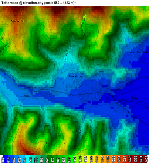
Below is the Elevation map of Tettorosso, which displays elevation range with different colors. Scale of the first map is from 582 to 1423 m (1909 to 4669 ft) with average elevation of 838 meters (=2749 ft) [note 1]
These maps also provides idea of topography and contour of this city, they are displayed at different zoom levels. More info about maps, scale and edge coordinates you can find below images.
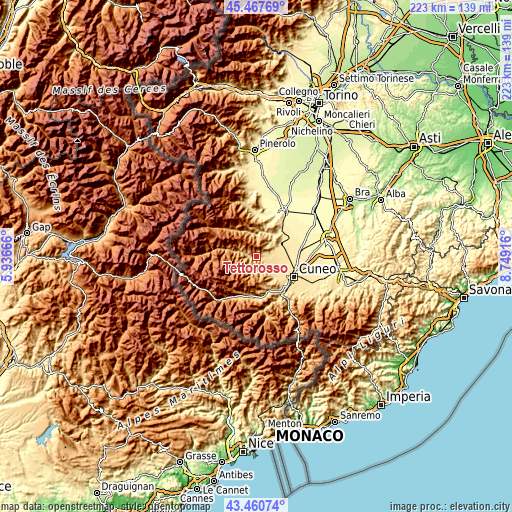
| \ | Map #1 | Topo.Map |
| Scale [m] | 582..1423 m | × |
| Scale [ft] | 1909..4669 ft | × |
| Average | 838 m = 2749 ft | × |
| Width | 6.97 km = 4.3 mi | 223.2 km = 138.7 mi |
| Height | 6.97 km = 4.3 mi | 223.1 km = 138.6 mi |
| ↑Max Latitude | 44.50419° | 45.46769° |
| Latitude at center | 44.47284° | 44.47284° |
| ↓Min Latitude | 44.441473° | 43.46074° |
| ← Min Longitude | 7.298965° | 5.93666° |
| Longitude center | 7.34291° | 7.34291° |
| →Max Longitude | 7.386855° | 8.74916° |
Nearby cities:
Cities around Tettorosso sort by population:
• Dronero elevation 599 m
1.8 km,  120°
120°
• Caraglio 581 m
9.4 km,  130°
130°
• Roccabruna 668 m
0.2 km,  19°
19°
• Villar San Costanzo 620 m
3.4 km,  67°
67°
• Valgrana 639 m
7.4 km,  156°
156°
• San Damiano Macra 756 m
7.1 km,  284°
284°
• Monterosso Grana 730 m
7.4 km,  192°
192°
• Pradleves 810 m
7.8 km,  218°
218°
• Melle 695 m
10.1 km,  349°
349°
• Cartignano 685 m
4.6 km, 277°
• Montemale di Cuneo 924 m
4.7 km,  146°
146°
• Valmala 833 m
7.9 km,  1°
1°
Multilingual:
 En español:
Tettorosso elevación 661 m.
 En France:
Tettorosso élévation 661 m.
 Auf Deutsch:
Tettorosso höhe über dem Meeresspiegel ist 661 m.

Sources and notes:
- [note 1] Map square and city borders are not equal. Map elevation data is calculated only from area inside that square.
- [src 1] Elevation data from geonames database provided with same terms of usage.
- [src 2] The elevation map of Tettorosso is generated using elevation data from NASA's 3 arcsec (90m) resolution SRTM data.
- [src 3] Base (background) map © OpenStreetMap contributors tiles are generated by Geofabrik and OpenTopoMap.
Copyright & License:
This Tettorosso Elevation Map is licensed under CC BY-SA. You may reuse any part from this page, if you give a proper credit by linking to this URL:
 More info on terms of use page.