Prosto elevation
Prosto (Lombardy, Provincia di Sondrio), Italy elevation is 395 meters and Prosto elevation in feet is 1296 ft above sea level [src 1]. Prosto is a seat of a third-order administrative division (feature code) with elevation that is 73 meters (240 ft) bigger than average city elevation in Italy.
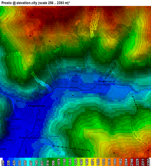
Below is the Elevation map of Prosto, which displays elevation range with different colors. Scale of the first map is from 256 to 2393 m (840 to 7851 ft) with average elevation of 1080 meters (=3543 ft) [note 1]
These maps also provides idea of topography and contour of this city, they are displayed at different zoom levels. More info about maps, scale and edge coordinates you can find below images.
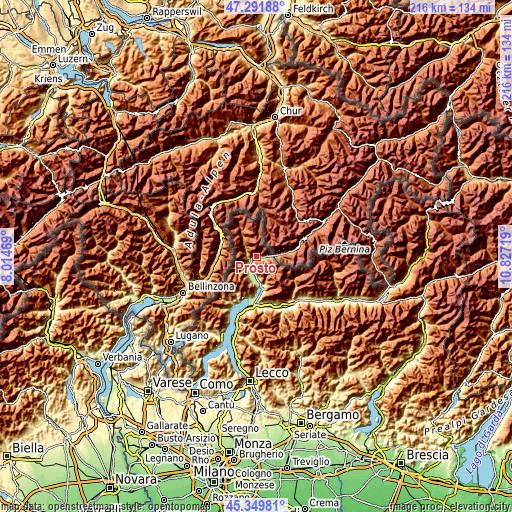
| \ | Map #1 | Topo.Map |
| Scale [m] | 256..2393 m | × |
| Scale [ft] | 840..7851 ft | × |
| Average | 1080 m = 3543 ft | × |
| Width | 6.75 km = 4.2 mi | 215.9 km = 134.2 mi |
| Height | 6.75 km = 4.2 mi | 215.9 km = 134.2 mi |
| ↑Max Latitude | 46.359796° | 47.29188° |
| Latitude at center | 46.32946° | 46.32946° |
| ↓Min Latitude | 46.299107° | 45.34981° |
| ← Min Longitude | 9.376995° | 8.01469° |
| Longitude center | 9.42094° | 9.42094° |
| →Max Longitude | 9.464885° | 10.82719° |
Nearby cities:
Cities around Prosto sort by population:
• Chiavenna elevation 327 m
2 km,  240°
240°
• Prata Camportaccio 305 m
3.2 km,  218°
218°
• Piuro 400 m
0 km,  327°
327°
• San Vittore 290 m
3.8 km,  230°
230°
• Mese 267 m
4.4 km, 229°
• Gordona 299 m
5.9 km, 224°
• San Cassiano 229 m
6.1 km,  197°
197°
• Prata Centro 302 m
3 km, 219°
• Villa di Chiavenna 618 m
4.6 km,  88°
88°
• Villa 647 m
4.9 km, 88°
• San Giacomo Filippo 537 m
3.9 km,  283°
283°
• Menarola 530 m
5.7 km, 233°
Multilingual:
 En español:
Prosto elevación 395 m.
 En France:
Prosto élévation 395 m.


Sources and notes:
- [note 1] Map square and city borders are not equal. Map elevation data is calculated only from area inside that square.
- [src 1] Elevation data from geonames database provided with same terms of usage.
- [src 2] The elevation map of Prosto is generated using elevation data from NASA's 3 arcsec (90m) resolution SRTM data.
- [src 3] Base (background) map © OpenStreetMap contributors tiles are generated by Geofabrik and OpenTopoMap.
Copyright & License:
This Prosto Elevation Map is licensed under CC BY-SA. You may reuse any part from this page, if you give a proper credit by linking to this URL:
 More info on terms of use page.