Montalto elevation
Montalto (Tuscany, Province of Arezzo), Italy elevation is 246 meters and Montalto elevation in feet is 807 ft above sea level [src 1]. Montalto is a populated place (feature code) with elevation that is 76 meters (249 ft) smaller than average city elevation in Italy.
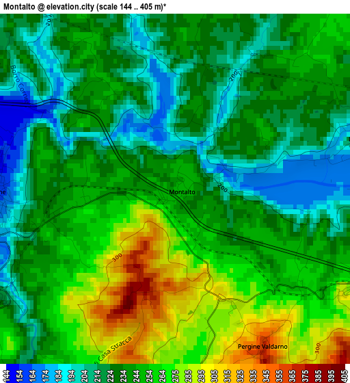
Below is the Elevation map of Montalto, which displays elevation range with different colors. Scale of the first map is from 144 to 405 m (472 to 1329 ft) with average elevation of 242 meters (=794 ft) [note 1]
These maps also provides idea of topography and contour of this city, they are displayed at different zoom levels. More info about maps, scale and edge coordinates you can find below images.
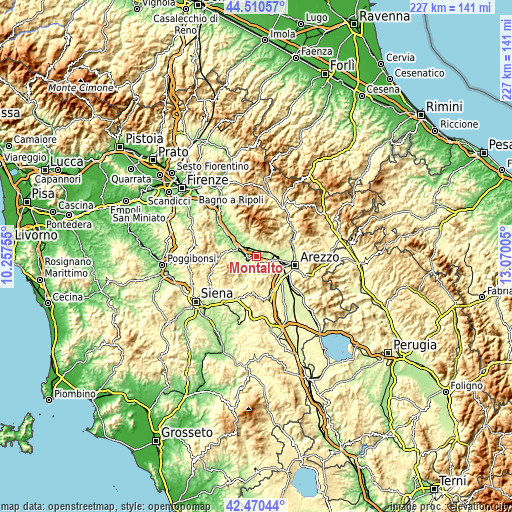
| \ | Map #1 | Topo.Map |
| Scale [m] | 144..405 m | × |
| Scale [ft] | 472..1329 ft | × |
| Average | 242 m = 794 ft | × |
| Width | 7.09 km = 4.4 mi | 226.8 km = 140.9 mi |
| Height | 7.09 km = 4.4 mi | 226.8 km = 140.9 mi |
| ↑Max Latitude | 43.530989° | 44.51057° |
| Latitude at center | 43.49912° | 43.49912° |
| ↓Min Latitude | 43.467234° | 42.47044° |
| ← Min Longitude | 11.619855° | 10.25755° |
| Longitude center | 11.6638° | 11.6638° |
| →Max Longitude | 11.707745° | 13.07005° |
Nearby cities:
Cities around Montalto sort by population:
• Montevarchi elevation 147 m
7.9 km,  291°
291°
• Terranuova Bracciolini 155 m
8.8 km,  310°
310°
• Loro Ciuffenna 310 m
10.3 km,  344°
344°
• Bucine 234 m
4.7 km,  238°
238°
• Castiglion Fibocchi 276 m
8.5 km,  68°
68°
• San Giustino Valdarno 299 m
6.8 km,  29°
29°
• Ponticino 259 m
4.7 km,  116°
116°
• Laterina 177 m
4.3 km,  85°
85°
• Ambra 254 m
10.6 km,  207°
207°
• Viciomaggio 273 m
11.5 km,  130°
130°
• Pergine Valdarno 368 m
3.7 km,  151°
151°
• Civitella in Val di Chiana 507 m
10.3 km, 152°
Multilingual:
 En español:
Montalto elevación 246 m.
 En France:
Montalto élévation 246 m.
 Auf Deutsch:
Montalto höhe über dem Meeresspiegel ist 246 m.

Sources and notes:
- [note 1] Map square and city borders are not equal. Map elevation data is calculated only from area inside that square.
- [src 1] Elevation data from geonames database provided with same terms of usage.
- [src 2] The elevation map of Montalto is generated using elevation data from NASA's 3 arcsec (90m) resolution SRTM data.
- [src 3] Base (background) map © OpenStreetMap contributors tiles are generated by Geofabrik and OpenTopoMap.
Copyright & License:
This Montalto Elevation Map is licensed under CC BY-SA. You may reuse any part from this page, if you give a proper credit by linking to this URL:
 More info on terms of use page.