Furato elevation
Furato (Lombardy, Città metropolitana di Milano), Italy elevation is 162 meters and Furato elevation in feet is 531 ft above sea level [src 1]. Furato is a populated place (feature code) with elevation that is 160 meters (525 ft) smaller than average city elevation in Italy.
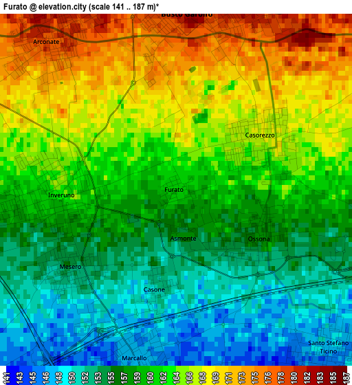
Below is the Elevation map of Furato, which displays elevation range with different colors. Scale of the first map is from 141 to 187 m (463 to 614 ft) with average elevation of 160.8 meters (=528 ft) [note 1]
These maps also provides idea of topography and contour of this city, they are displayed at different zoom levels. More info about maps, scale and edge coordinates you can find below images.
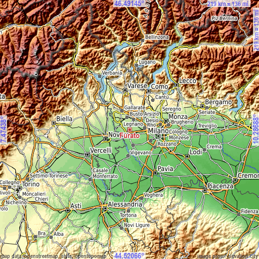
| \ | Map #1 | Topo.Map |
| Scale [m] | 141..187 m | × |
| Scale [ft] | 463..614 ft | × |
| Average | 160.8 m = 528 ft | × |
| Width | 6.85 km = 4.3 mi | 219.1 km = 136.1 mi |
| Height | 6.85 km = 4.3 mi | 219.1 km = 136.1 mi |
| ↑Max Latitude | 45.545465° | 46.49145° |
| Latitude at center | 45.51468° | 45.51468° |
| ↓Min Latitude | 45.483878° | 44.52066° |
| ← Min Longitude | 8.836685° | 7.47438° |
| Longitude center | 8.88063° | 8.88063° |
| →Max Longitude | 8.924575° | 10.28688° |
Nearby cities:
Cities around Furato sort by population:
• Busto Garolfo elevation 187 m
3.7 km,  2°
2°
• Arluno 155 m
5 km,  104°
104°
• Cuggiono 158 m
5.1 km,  260°
260°
• Inveruno 162 m
2.4 km,  268°
268°
• Arconate 178 m
3.9 km,  320°
320°
• Casorezzo 165 m
1.9 km,  61°
61°
• Santo Stefano Ticino 149 m
4.2 km,  138°
138°
• Marcallo 147 m
3.6 km,  190°
190°
• Ossona 157 m
1.3 km,  130°
130°
• Mesero 154 m
2.4 km,  234°
234°
• Casone 153 m
1.9 km, 190°
• Casate 149 m
4.8 km,  238°
238°
Multilingual:
 En español:
Furato elevación 162 m.
 En France:
Furato élévation 162 m.


Sources and notes:
- [note 1] Map square and city borders are not equal. Map elevation data is calculated only from area inside that square.
- [src 1] Elevation data from geonames database provided with same terms of usage.
- [src 2] The elevation map of Furato is generated using elevation data from NASA's 3 arcsec (90m) resolution SRTM data.
- [src 3] Base (background) map © OpenStreetMap contributors tiles are generated by Geofabrik and OpenTopoMap.
Copyright & License:
This Furato Elevation Map is licensed under CC BY-SA. You may reuse any part from this page, if you give a proper credit by linking to this URL:
 More info on terms of use page.