Borgo elevation
Borgo (Piedmont, Provincia di Cuneo), Italy elevation is 189 meters and Borgo elevation in feet is 620 ft above sea level [src 1]. Borgo is a populated place (feature code) with elevation that is 133 meters (436 ft) smaller than average city elevation in Italy.
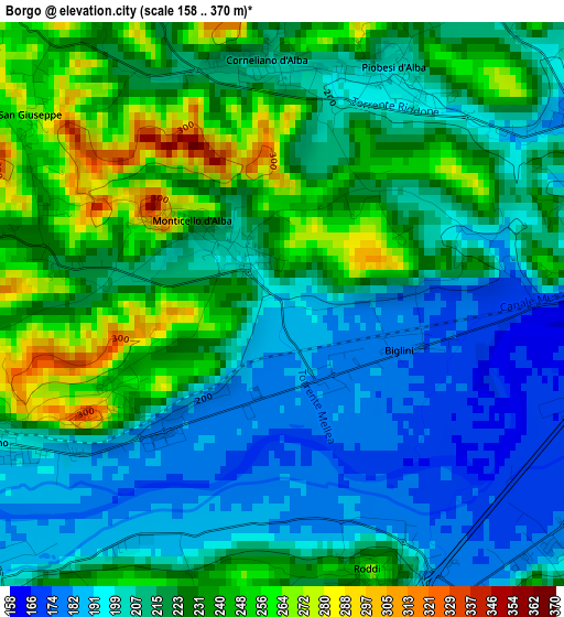
Below is the Elevation map of Borgo, which displays elevation range with different colors. Scale of the first map is from 158 to 370 m (518 to 1214 ft) with average elevation of 217.9 meters (=715 ft) [note 1]
These maps also provides idea of topography and contour of this city, they are displayed at different zoom levels. More info about maps, scale and edge coordinates you can find below images.
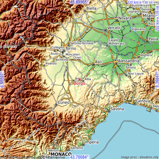
| \ | Map #1 | Topo.Map |
| Scale [m] | 158..370 m | × |
| Scale [ft] | 518..1214 ft | × |
| Average | 217.9 m = 715 ft | × |
| Width | 6.95 km = 4.3 mi | 222.2 km = 138.1 mi |
| Height | 6.95 km = 4.3 mi | 222.2 km = 138.1 mi |
| ↑Max Latitude | 44.740093° | 45.69965° |
| Latitude at center | 44.70887° | 44.70887° |
| ↓Min Latitude | 44.67763° | 43.70084° |
| ← Min Longitude | 7.918275° | 6.55597° |
| Longitude center | 7.96222° | 7.96222° |
| →Max Longitude | 8.006165° | 9.36847° |
Nearby cities:
Cities around Borgo sort by population:
• Alba elevation 178 m
5.8 km,  99°
99°
• Mussotto 165 m
5.8 km,  80°
80°
• Santa Vittoria d'Alba 243 m
2.3 km,  239°
239°
• Monticello d'Alba 341 m
1.9 km,  305°
305°
• Corneliano d'Alba 209 m
3.1 km,  352°
352°
• Cinzano 195 m
3.7 km, 241°
• Roddi 246 m
3.4 km,  162°
162°
• Piobesi d'Alba 197 m
3.1 km,  25°
25°
• Villa-Borgo 264 m
2.4 km, 242°
• Pocapaglia 279 m
6.3 km,  276°
276°
• Verduno 355 m
5.4 km,  207°
207°
• Villa 358 m
2 km,  304°
304°
Multilingual:
 En español:
Borgo elevación 189 m.
 En France:
Borgo élévation 189 m.


Sources and notes:
- [note 1] Map square and city borders are not equal. Map elevation data is calculated only from area inside that square.
- [src 1] Elevation data from geonames database provided with same terms of usage.
- [src 2] The elevation map of Borgo is generated using elevation data from NASA's 3 arcsec (90m) resolution SRTM data.
- [src 3] Base (background) map © OpenStreetMap contributors tiles are generated by Geofabrik and OpenTopoMap.
Copyright & License:
This Borgo Elevation Map is licensed under CC BY-SA. You may reuse any part from this page, if you give a proper credit by linking to this URL:
 More info on terms of use page.