Vigardolo elevation
Vigardolo (Veneto, Provincia di Vicenza), Italy elevation is 41 meters and Vigardolo elevation in feet is 135 ft above sea level [src 1]. Vigardolo is a populated place (feature code) with elevation that is 281 meters (922 ft) smaller than average city elevation in Italy.
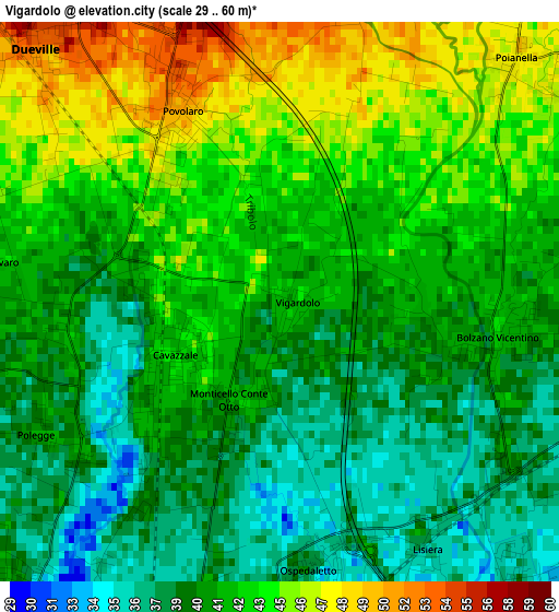
Below is the Elevation map of Vigardolo, which displays elevation range with different colors. Scale of the first map is from 29 to 60 m (95 to 197 ft) with average elevation of 41.5 meters (=136 ft) [note 1]
These maps also provides idea of topography and contour of this city, they are displayed at different zoom levels. More info about maps, scale and edge coordinates you can find below images.
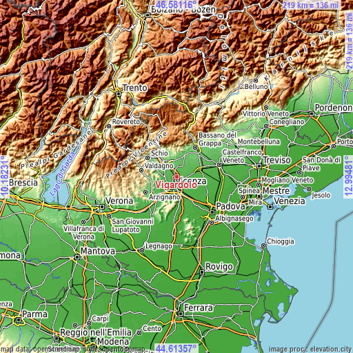
| \ | Map #1 | Topo.Map |
| Scale [m] | 29..60 m | × |
| Scale [ft] | 95..197 ft | × |
| Average | 41.5 m = 136 ft | × |
| Width | 6.84 km = 4.3 mi | 218.8 km = 136 mi |
| Height | 6.84 km = 4.3 mi | 218.8 km = 136 mi |
| ↑Max Latitude | 45.636725° | 46.58116° |
| Latitude at center | 45.60599° | 45.60599° |
| ↓Min Latitude | 45.575238° | 44.61357° |
| ← Min Longitude | 11.544615° | 10.18231° |
| Longitude center | 11.58856° | 11.58856° |
| →Max Longitude | 11.632505° | 12.99481° |
Nearby cities:
Cities around Vigardolo sort by population:
• Dueville elevation 55 m
4.4 km,  318°
318°
• Caldogno-Rettorgole-Cresole 49 m
6.7 km,  271°
271°
• Monticello Conte Otto 43 m
1.6 km,  234°
234°
• Sandrigo 68 m
6.1 km,  0°
0°
• Bolzano Vicentino 43 m
2.6 km,  99°
99°
• San Pietro in Gu 42 m
6.6 km,  87°
87°
• Quinto Vicentino 34 m
4.6 km,  137°
137°
• Poianella 47 m
4.1 km,  48°
48°
• Bressanvido 52 m
5.7 km,  38°
38°
• Lisiera 36 m
3.6 km,  149°
149°
• Villaggio Montegrappa 33 m
6.9 km,  163°
163°
• Montecchio Precalcino 80 m
6.9 km,  343°
343°
Multilingual:
 En español:
Vigardolo elevación 41 m.
 En France:
Vigardolo élévation 41 m.
 Auf Deutsch:
Vigardolo höhe über dem Meeresspiegel ist 41 m.

Sources and notes:
- [note 1] Map square and city borders are not equal. Map elevation data is calculated only from area inside that square.
- [src 1] Elevation data from geonames database provided with same terms of usage.
- [src 2] The elevation map of Vigardolo is generated using elevation data from NASA's 3 arcsec (90m) resolution SRTM data.
- [src 3] Base (background) map © OpenStreetMap contributors tiles are generated by Geofabrik and OpenTopoMap.
Copyright & License:
This Vigardolo Elevation Map is licensed under CC BY-SA. You may reuse any part from this page, if you give a proper credit by linking to this URL:
 More info on terms of use page.