Lavinaio-Monterosso elevation
Lavinaio-Monterosso (Sicily, Catania), Italy elevation is 447 meters and Lavinaio-Monterosso elevation in feet is 1467 ft above sea level [src 1]. Lavinaio-Monterosso is a populated place (feature code) with elevation that is 125 meters (410 ft) bigger than average city elevation in Italy.
Below is the Elevation map of Lavinaio-Monterosso, which displays elevation range with different colors. Scale of the first map is from 174 to 1154 m (571 to 3786 ft) with average elevation of 485.6 meters (=1593 ft) [note 1]
These maps also provides idea of topography and contour of this city, they are displayed at different zoom levels. More info about maps, scale and edge coordinates you can find below images.
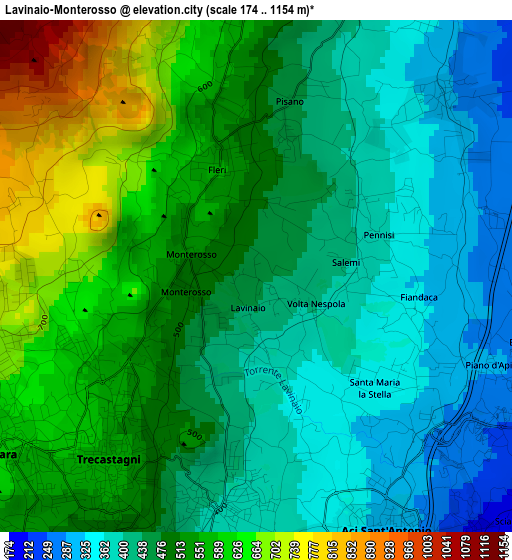
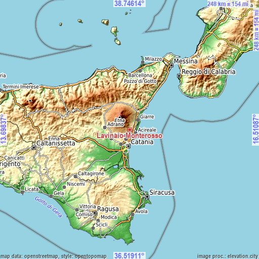
| \ | Map #1 | Topo.Map |
| Scale [m] | 174..1154 m | × |
| Scale [ft] | 571..3786 ft | × |
| Average | 485.6 m = 1593 ft | × |
| Width | 7.74 km = 4.8 mi | 247.6 km = 153.9 mi |
| Height | 7.74 km = 4.8 mi | 247.6 km = 153.9 mi |
| ↑Max Latitude | 37.67576° | 38.74614° |
| Latitude at center | 37.64097° | 37.64097° |
| ↓Min Latitude | 37.606164° | 36.51911° |
| ← Min Longitude | 15.060675° | 13.69837° |
| Longitude center | 15.10462° | 15.10462° |
| →Max Longitude | 15.148565° | 16.51087° |
Nearby cities:
Cities around Lavinaio-Monterosso sort by population:
• Aci Catena elevation 203 m
5.1 km,  139°
139°
• Pedara 675 m
4.6 km,  245°
245°
• Aci Sant'Antonio 318 m
4.3 km,  158°
158°
• Trecastagni 574 m
3.7 km,  219°
219°
• Zafferana Etnea 548 m
4.2 km,  359°
359°
• Viagrande 399 m
3.5 km,  189°
189°
• Santa Venerina 349 m
6.3 km,  28°
28°
• Santa Maria la Stella 341 m
2.4 km, 143°
• Aci Bonaccorsi 364 m
5 km,  177°
177°
• Linera 299 m
3.8 km,  47°
47°
• Maugeri 348 m
6.2 km,  169°
169°
• Pennisi 377 m
1.9 km,  60°
60°
Multilingual:
 En español:
Lavinaio-Monterosso elevación 447 m.
 En France:
Lavinaio-Monterosso élévation 447 m.
 Auf Deutsch:
Lavinaio-Monterosso höhe über dem Meeresspiegel ist 447 m.
 На русском:
Lavinaio-Monterosso высота над уровнем моря 447 м
Sources and notes:
- [note 1] Map square and city borders are not equal. Map elevation data is calculated only from area inside that square.
- [src 1] Elevation data from geonames database provided with same terms of usage.
- [src 2] The elevation map of Lavinaio-Monterosso is generated using elevation data from NASA's 3 arcsec (90m) resolution SRTM data.
- [src 3] Base (background) map © OpenStreetMap contributors tiles are generated by Geofabrik and OpenTopoMap.
Copyright & License:
This Lavinaio-Monterosso Elevation Map is licensed under CC BY-SA. You may reuse any part from this page, if you give a proper credit by linking to this URL:
 More info on terms of use page.