Lodetto elevation
Lodetto (Lombardy, Provincia di Brescia), Italy elevation is 155 meters and Lodetto elevation in feet is 509 ft above sea level [src 1]. Lodetto is a populated place (feature code) with elevation that is 167 meters (548 ft) smaller than average city elevation in Italy.
Below is the Elevation map of Lodetto, which displays elevation range with different colors. Scale of the first map is from 117 to 260 m (384 to 853 ft) with average elevation of 155.5 meters (=510 ft) [note 1]
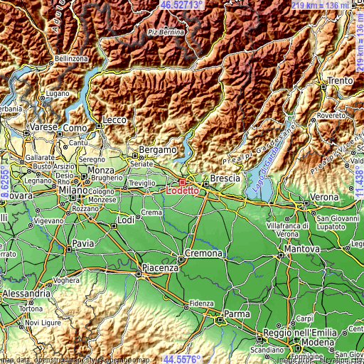
These maps also provides idea of topography and contour of this city, they are displayed at different zoom levels. More info about maps, scale and edge coordinates you can find below images.
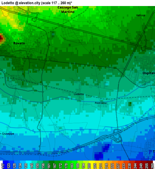
| \ | Map #1 | Topo.Map |
| Scale [m] | 117..260 m | × |
| Scale [ft] | 384..853 ft | × |
| Average | 155.5 m = 510 ft | × |
| Width | 6.84 km = 4.3 mi | 219 km = 136.1 mi |
| Height | 6.84 km = 4.3 mi | 219 km = 136.1 mi |
| ↑Max Latitude | 45.581755° | 46.52713° |
| Latitude at center | 45.55099° | 45.55099° |
| ↓Min Latitude | 45.520208° | 44.5576° |
| ← Min Longitude | 9.987805° | 8.6255° |
| Longitude center | 10.03175° | 10.03175° |
| →Max Longitude | 10.075695° | 11.438° |
Nearby cities:
Cities around Lodetto sort by population:
• Ospitaletto elevation 152 m
3.4 km,  87°
87°
• Travagliato 129 m
4.8 km,  128°
128°
• Rovato 169 m
2.7 km,  300°
300°
• Coccaglio 159 m
4.9 km,  287°
287°
• Passirano 198 m
5.9 km,  30°
30°
• Cazzago San Martino-Calino 202 m
3.8 km,  349°
349°
• Paderno Franciacorta 177 m
5.5 km,  43°
43°
• Bornato 222 m
4.8 km,  8°
8°
• Villa Pedergnano 209 m
4.8 km,  322°
322°
• Berlingo 121 m
5.4 km,  177°
177°
• Costa-Barco 192 m
3.6 km, 8°
• Duomo 145 m
2.2 km,  201°
201°
Multilingual:
 En español:
Lodetto elevación 155 m.
 En France:
Lodetto élévation 155 m.


Sources and notes:
- [note 1] Map square and city borders are not equal. Map elevation data is calculated only from area inside that square.
- [src 1] Elevation data from geonames database provided with same terms of usage.
- [src 2] The elevation map of Lodetto is generated using elevation data from NASA's 3 arcsec (90m) resolution SRTM data.
- [src 3] Base (background) map © OpenStreetMap contributors tiles are generated by Geofabrik and OpenTopoMap.
Copyright & License:
This Lodetto Elevation Map is licensed under CC BY-SA. You may reuse any part from this page, if you give a proper credit by linking to this URL:
 More info on terms of use page.