Figliaro elevation
Figliaro (Lombardy, Provincia di Como), Italy elevation is 430 meters and Figliaro elevation in feet is 1411 ft above sea level [src 1]. Figliaro is a seat of a third-order administrative division (feature code) with elevation that is 108 meters (354 ft) bigger than average city elevation in Italy.
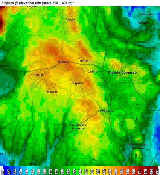
Below is the Elevation map of Figliaro, which displays elevation range with different colors. Scale of the first map is from 320 to 491 m (1050 to 1611 ft) with average elevation of 398.9 meters (=1309 ft) [note 1]
These maps also provides idea of topography and contour of this city, they are displayed at different zoom levels. More info about maps, scale and edge coordinates you can find below images.
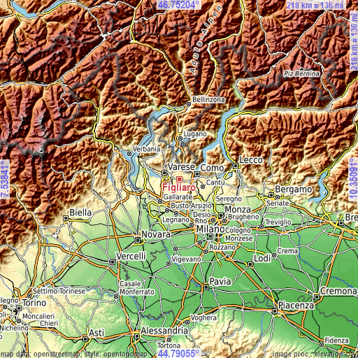
| \ | Map #1 | Topo.Map |
| Scale [m] | 320..491 m | × |
| Scale [ft] | 1050..1611 ft | × |
| Average | 398.9 m = 1309 ft | × |
| Width | 6.82 km = 4.2 mi | 218.1 km = 135.5 mi |
| Height | 6.82 km = 4.2 mi | 218.1 km = 135.5 mi |
| ↑Max Latitude | 45.81056° | 46.75204° |
| Latitude at center | 45.77992° | 45.77992° |
| ↓Min Latitude | 45.749263° | 44.79055° |
| ← Min Longitude | 8.900715° | 7.53841° |
| Longitude center | 8.94466° | 8.94466° |
| →Max Longitude | 8.988605° | 10.35091° |
Nearby cities:
Cities around Figliaro sort by population:
• Olgiate Comasco elevation 408 m
1.9 km,  74°
74°
• Binago 431 m
1.7 km,  278°
278°
• Faloppio 383 m
3.6 km,  24°
24°
• Gaggino 376 m
3.5 km,  26°
26°
• Albiolo 426 m
2.9 km,  351°
351°
• Beregazzo con Figliaro 432 m
0.1 km,  334°
334°
• Oltrona di San Mamette 374 m
3.7 km,  137°
137°
• Cagno 414 m
4.1 km, 328°
• Solbiate 451 m
1.4 km,  320°
320°
• Camnago-Boscone 366 m
3.9 km,  44°
44°
• Beregazzo 406 m
1.5 km,  134°
134°
• Castelnuovo Bozzente 409 m
1.7 km,  182°
182°
Multilingual:
 En español:
Figliaro elevación 430 m.
 En France:
Figliaro élévation 430 m.
 Auf Deutsch:
Figliaro höhe über dem Meeresspiegel ist 430 m.

Sources and notes:
- [note 1] Map square and city borders are not equal. Map elevation data is calculated only from area inside that square.
- [src 1] Elevation data from geonames database provided with same terms of usage.
- [src 2] The elevation map of Figliaro is generated using elevation data from NASA's 3 arcsec (90m) resolution SRTM data.
- [src 3] Base (background) map © OpenStreetMap contributors tiles are generated by Geofabrik and OpenTopoMap.
Copyright & License:
This Figliaro Elevation Map is licensed under CC BY-SA. You may reuse any part from this page, if you give a proper credit by linking to this URL:
 More info on terms of use page.