Mantegazza elevation
Mantegazza (Lombardy, Città metropolitana di Milano), Italy elevation is 157 meters and Mantegazza elevation in feet is 515 ft above sea level [src 1]. Mantegazza is a populated place (feature code) with elevation that is 165 meters (541 ft) smaller than average city elevation in Italy.
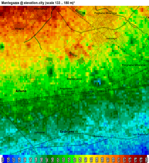
Below is the Elevation map of Mantegazza, which displays elevation range with different colors. Scale of the first map is from 133 to 180 m (436 to 591 ft) with average elevation of 154.2 meters (=506 ft) [note 1]
These maps also provides idea of topography and contour of this city, they are displayed at different zoom levels. More info about maps, scale and edge coordinates you can find below images.
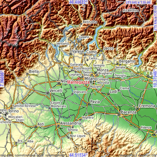
| \ | Map #1 | Topo.Map |
| Scale [m] | 133..180 m | × |
| Scale [ft] | 436..591 ft | × |
| Average | 154.2 m = 506 ft | × |
| Width | 6.85 km = 4.3 mi | 219.2 km = 136.2 mi |
| Height | 6.85 km = 4.3 mi | 219.1 km = 136.1 mi |
| ↑Max Latitude | 45.540248° | 46.48632° |
| Latitude at center | 45.50946° | 45.50946° |
| ↓Min Latitude | 45.478655° | 44.51534° |
| ← Min Longitude | 8.929265° | 7.56696° |
| Longitude center | 8.97321° | 8.97321° |
| →Max Longitude | 9.017155° | 10.37946° |
Nearby cities:
Cities around Mantegazza sort by population:
• Cornaredo elevation 147 m
4.3 km,  102°
102°
• Nerviano 173 m
4.9 km,  5°
5°
• Bareggio 141 m
3.9 km,  150°
150°
• Sedriano 148 m
2.1 km,  183°
183°
• Arluno 155 m
2.5 km,  254°
254°
• Vittuone 147 m
2.9 km,  215°
215°
• Pogliano Milanese 166 m
3.5 km,  27°
27°
• Vanzago 164 m
2.3 km,  37°
37°
• Pregnana Milanese 153 m
2.7 km,  74°
74°
• Casorezzo 165 m
5.7 km,  284°
284°
• Santo Stefano Ticino 149 m
5.2 km,  240°
240°
• Vighignolo 143 m
5.7 km,  105°
105°
Multilingual:
 En español:
Mantegazza elevación 157 m.
 En France:
Mantegazza élévation 157 m.
 Auf Deutsch:
Mantegazza höhe über dem Meeresspiegel ist 157 m.

Sources and notes:
- [note 1] Map square and city borders are not equal. Map elevation data is calculated only from area inside that square.
- [src 1] Elevation data from geonames database provided with same terms of usage.
- [src 2] The elevation map of Mantegazza is generated using elevation data from NASA's 3 arcsec (90m) resolution SRTM data.
- [src 3] Base (background) map © OpenStreetMap contributors tiles are generated by Geofabrik and OpenTopoMap.
Copyright & License:
This Mantegazza Elevation Map is licensed under CC BY-SA. You may reuse any part from this page, if you give a proper credit by linking to this URL:
 More info on terms of use page.