Premenugo elevation
Premenugo (Lombardy, Città metropolitana di Milano), Italy elevation is 106 meters and Premenugo elevation in feet is 348 ft above sea level [src 1]. Premenugo is a populated place (feature code) with elevation that is 216 meters (709 ft) smaller than average city elevation in Italy.
Below is the Elevation map of Premenugo, which displays elevation range with different colors. Scale of the first map is from 94 to 138 m (308 to 453 ft) with average elevation of 108.1 meters (=355 ft) [note 1]
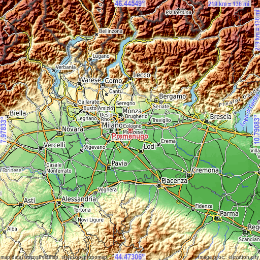
These maps also provides idea of topography and contour of this city, they are displayed at different zoom levels. More info about maps, scale and edge coordinates you can find below images.
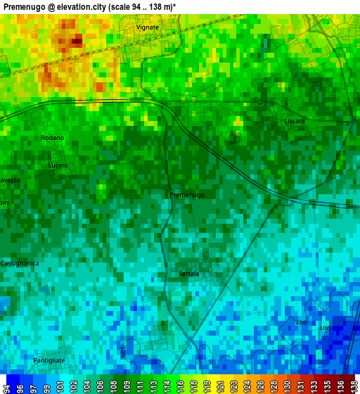
| \ | Map #1 | Topo.Map |
| Scale [m] | 94..138 m | × |
| Scale [ft] | 308..453 ft | × |
| Average | 108.1 m = 355 ft | × |
| Width | 6.85 km = 4.3 mi | 219.3 km = 136.3 mi |
| Height | 6.85 km = 4.3 mi | 219.3 km = 136.3 mi |
| ↑Max Latitude | 45.498711° | 46.44549° |
| Latitude at center | 45.4679° | 45.4679° |
| ↓Min Latitude | 45.437072° | 44.47306° |
| ← Min Longitude | 9.340635° | 7.97833° |
| Longitude center | 9.38458° | 9.38458° |
| →Max Longitude | 9.428525° | 10.79083° |
Nearby cities:
Cities around Premenugo sort by population:
• Melzo elevation 121 m
4.4 km,  39°
39°
• Paullo 99 m
5.6 km,  167°
167°
• Vignate 122 m
3.5 km,  350°
350°
• Pantigliate 100 m
4.4 km,  214°
214°
• Liscate 110 m
2.6 km,  49°
49°
• Mombretto 100 m
5.1 km,  197°
197°
• Vigliano-Bettolino 101 m
5 km,  218°
218°
• Caleppio 101 m
3.7 km,  182°
182°
• Settala 105 m
1.6 km, 172°
• Millepini 112 m
3.7 km,  273°
273°
• Lucino-Rodano 114 m
2.6 km,  290°
290°
• Merlino 98 m
5.2 km,  137°
137°
Multilingual:
 En español:
Premenugo elevación 106 m.
 En France:
Premenugo élévation 106 m.
 Auf Deutsch:
Premenugo höhe über dem Meeresspiegel ist 106 m.

Sources and notes:
- [note 1] Map square and city borders are not equal. Map elevation data is calculated only from area inside that square.
- [src 1] Elevation data from geonames database provided with same terms of usage.
- [src 2] The elevation map of Premenugo is generated using elevation data from NASA's 3 arcsec (90m) resolution SRTM data.
- [src 3] Base (background) map © OpenStreetMap contributors tiles are generated by Geofabrik and OpenTopoMap.
Copyright & License:
This Premenugo Elevation Map is licensed under CC BY-SA. You may reuse any part from this page, if you give a proper credit by linking to this URL:
 More info on terms of use page.