Quaderni elevation
Quaderni (Veneto, Provincia di Verona), Italy elevation is 63 meters and Quaderni elevation in feet is 207 ft above sea level [src 1]. Quaderni is a populated place (feature code) with elevation that is 259 meters (850 ft) smaller than average city elevation in Italy.
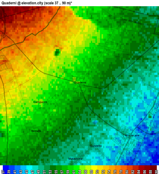
Below is the Elevation map of Quaderni, which displays elevation range with different colors. Scale of the first map is from 37 to 90 m (121 to 295 ft) with average elevation of 59.1 meters (=194 ft) [note 1]
These maps also provides idea of topography and contour of this city, they are displayed at different zoom levels. More info about maps, scale and edge coordinates you can find below images.
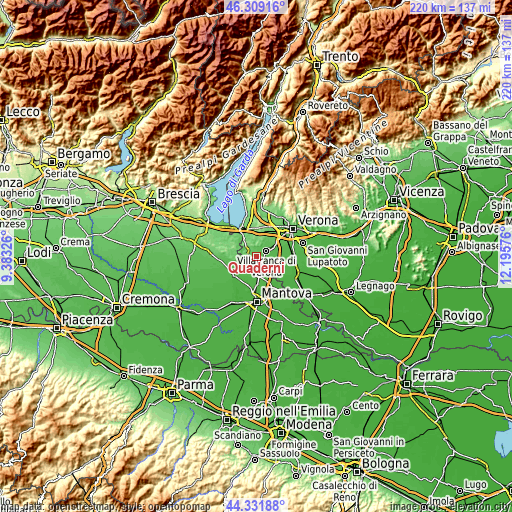
| \ | Map #1 | Topo.Map |
| Scale [m] | 37..90 m | × |
| Scale [ft] | 121..295 ft | × |
| Average | 59.1 m = 194 ft | × |
| Width | 6.87 km = 4.3 mi | 219.9 km = 136.6 mi |
| Height | 6.87 km = 4.3 mi | 219.8 km = 136.6 mi |
| ↑Max Latitude | 45.360037° | 46.30916° |
| Latitude at center | 45.32915° | 45.32915° |
| ↓Min Latitude | 45.298247° | 44.33188° |
| ← Min Longitude | 10.745565° | 9.38326° |
| Longitude center | 10.78951° | 10.78951° |
| →Max Longitude | 10.833455° | 12.19576° |
Nearby cities:
Cities around Quaderni sort by population:
• Villafranca di Verona elevation 51 m
5.1 km,  57°
57°
• Valeggio sul Mincio 90 m
4.9 km,  302°
302°
• Sommacampagna 95 m
9.5 km,  26°
26°
• Povegliano Veronese 48 m
7.4 km,  74°
74°
• Mozzecane 47 m
3.1 km,  139°
139°
• Roverbella 41 m
7.1 km,  192°
192°
• Monzambano 79 m
9.8 km,  309°
309°
• Malavicina 51 m
3.3 km,  183°
183°
• Salionze 92 m
9.9 km,  328°
328°
• Rosegaferro 61 m
2.2 km,  42°
42°
• Pradelle 35 m
8.2 km,  128°
128°
• Nogarole Rocca 35 m
8.5 km,  120°
120°
Multilingual:
 En español:
Quaderni elevación 63 m.
 En France:
Quaderni élévation 63 m.


Sources and notes:
- [note 1] Map square and city borders are not equal. Map elevation data is calculated only from area inside that square.
- [src 1] Elevation data from geonames database provided with same terms of usage.
- [src 2] The elevation map of Quaderni is generated using elevation data from NASA's 3 arcsec (90m) resolution SRTM data.
- [src 3] Base (background) map © OpenStreetMap contributors tiles are generated by Geofabrik and OpenTopoMap.
Copyright & License:
This Quaderni Elevation Map is licensed under CC BY-SA. You may reuse any part from this page, if you give a proper credit by linking to this URL:
 More info on terms of use page.