Campanella-Gianforma elevation
Campanella-Gianforma (Sicily, Ragusa), Italy elevation is 476 meters and Campanella-Gianforma elevation in feet is 1562 ft above sea level [src 1]. Campanella-Gianforma is a populated place (feature code) with elevation that is 154 meters (505 ft) bigger than average city elevation in Italy.
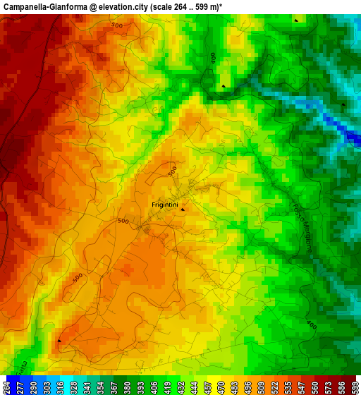
Below is the Elevation map of Campanella-Gianforma, which displays elevation range with different colors. Scale of the first map is from 264 to 599 m (866 to 1965 ft) with average elevation of 460.6 meters (=1511 ft) [note 1]
These maps also provides idea of topography and contour of this city, they are displayed at different zoom levels. More info about maps, scale and edge coordinates you can find below images.
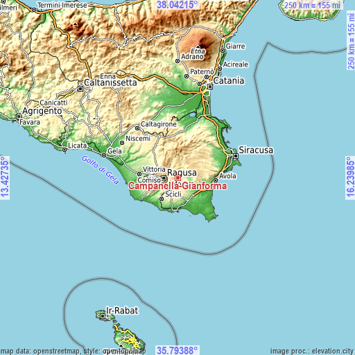
| \ | Map #1 | Topo.Map |
| Scale [m] | 264..599 m | × |
| Scale [ft] | 866..1965 ft | × |
| Average | 460.6 m = 1511 ft | × |
| Width | 7.81 km = 4.9 mi | 250 km = 155.3 mi |
| Height | 7.81 km = 4.9 mi | 250 km = 155.3 mi |
| ↑Max Latitude | 36.961422° | 38.04215° |
| Latitude at center | 36.9263° | 36.9263° |
| ↓Min Latitude | 36.891162° | 35.79388° |
| ← Min Longitude | 14.789655° | 13.42735° |
| Longitude center | 14.8336° | 14.8336° |
| →Max Longitude | 14.877545° | 16.23985° |
Nearby cities:
Cities around Campanella-Gianforma sort by population:
• Ragusa elevation 540 m
9.7 km,  269°
269°
• Modica 322 m
10 km,  221°
221°
• Comiso 204 m
20.3 km,  277°
277°
• Rosolini 145 m
15.7 km,  138°
138°
• Noto 138 m
21.3 km,  100°
100°
• Scicli 119 m
19.1 km, 217°
• Ispica 180 m
16.8 km,  157°
157°
• Palazzolo Acreide 668 m
16.5 km,  22°
22°
• Chiaramonte Gulfi 677 m
16.4 km,  314°
314°
• Monterosso Almo 674 m
19.1 km,  341°
341°
• Giarratana 521 m
13.9 km,  345°
345°
• Buscemi 757 m
18.3 km,  14°
14°
Multilingual:
 En español:
Campanella-Gianforma elevación 476 m.
 En France:
Campanella-Gianforma élévation 476 m.
 Auf Deutsch:
Campanella-Gianforma höhe über dem Meeresspiegel ist 476 m.
 На русском:
Campanella-Gianforma высота над уровнем моря 476 м
Sources and notes:
- [note 1] Map square and city borders are not equal. Map elevation data is calculated only from area inside that square.
- [src 1] Elevation data from geonames database provided with same terms of usage.
- [src 2] The elevation map of Campanella-Gianforma is generated using elevation data from NASA's 3 arcsec (90m) resolution SRTM data.
- [src 3] Base (background) map © OpenStreetMap contributors tiles are generated by Geofabrik and OpenTopoMap.
Copyright & License:
This Campanella-Gianforma Elevation Map is licensed under CC BY-SA. You may reuse any part from this page, if you give a proper credit by linking to this URL:
 More info on terms of use page.