Santo Stefano elevation
Santo Stefano (Calabria, Provincia di Cosenza), Italy elevation is 300 meters and Santo Stefano elevation in feet is 984 ft above sea level [src 1]. Santo Stefano is a populated place (feature code) with elevation that is 22 meters (72 ft) smaller than average city elevation in Italy.
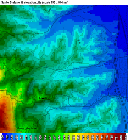
Below is the Elevation map of Santo Stefano, which displays elevation range with different colors. Scale of the first map is from 156 to 844 m (512 to 2769 ft) with average elevation of 302.8 meters (=993 ft) [note 1]
These maps also provides idea of topography and contour of this city, they are displayed at different zoom levels. More info about maps, scale and edge coordinates you can find below images.
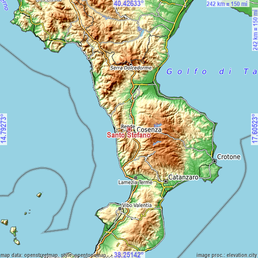
| \ | Map #1 | Topo.Map |
| Scale [m] | 156..844 m | × |
| Scale [ft] | 512..2769 ft | × |
| Average | 302.8 m = 993 ft | × |
| Width | 7.56 km = 4.7 mi | 241.8 km = 150.2 mi |
| Height | 7.56 km = 4.7 mi | 241.8 km = 150.2 mi |
| ↑Max Latitude | 39.381315° | 40.42633° |
| Latitude at center | 39.34734° | 39.34734° |
| ↓Min Latitude | 39.313348° | 38.25142° |
| ← Min Longitude | 16.155035° | 14.79273° |
| Longitude center | 16.19898° | 16.19898° |
| →Max Longitude | 16.242925° | 17.60523° |
Nearby cities:
Cities around Santo Stefano sort by population:
• Quattromiglia elevation 193 m
3.4 km,  94°
94°
• Andreotta 300 m
4.7 km,  160°
160°
• Marano Marchesato 467 m
4.4 km,  209°
209°
• Marano Principato 512 m
5.9 km,  201°
201°
• Settimo 171 m
6.1 km,  35°
35°
• Arcavacata 307 m
1.5 km,  33°
33°
• Surdo 257 m
2.2 km,  174°
174°
• Rende 464 m
2.4 km,  222°
222°
• San Fili 527 m
4.8 km,  259°
259°
• Rosario 343 m
6.8 km, 156°
• San Vincenzo la Costa 477 m
4.6 km,  296°
296°
• Castrolibero 513 m
4.2 km,  185°
185°
Multilingual:
 En español:
Santo Stefano elevación 300 m.
 En France:
Santo Stefano élévation 300 m.
 Auf Deutsch:
Santo Stefano höhe über dem Meeresspiegel ist 300 m.

Sources and notes:
- [note 1] Map square and city borders are not equal. Map elevation data is calculated only from area inside that square.
- [src 1] Elevation data from geonames database provided with same terms of usage.
- [src 2] The elevation map of Santo Stefano is generated using elevation data from NASA's 3 arcsec (90m) resolution SRTM data.
- [src 3] Base (background) map © OpenStreetMap contributors tiles are generated by Geofabrik and OpenTopoMap.
Copyright & License:
This Santo Stefano Elevation Map is licensed under CC BY-SA. You may reuse any part from this page, if you give a proper credit by linking to this URL:
 More info on terms of use page.