Sant'Agata Martesana elevation
Sant'Agata Martesana (Lombardy, Città metropolitana di Milano), Italy elevation is 132 meters and Sant'Agata Martesana elevation in feet is 433 ft above sea level [src 1]. Sant'Agata Martesana is a populated place (feature code) with elevation that is 190 meters (623 ft) smaller than average city elevation in Italy.
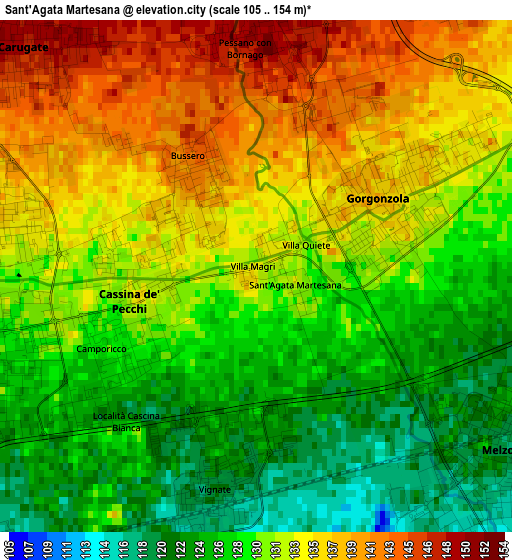
Below is the Elevation map of Sant'Agata Martesana, which displays elevation range with different colors. Scale of the first map is from 105 to 154 m (344 to 505 ft) with average elevation of 131 meters (=430 ft) [note 1]
These maps also provides idea of topography and contour of this city, they are displayed at different zoom levels. More info about maps, scale and edge coordinates you can find below images.
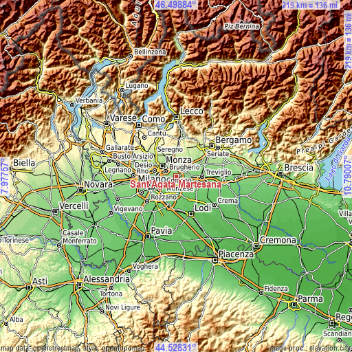
| \ | Map #1 | Topo.Map |
| Scale [m] | 105..154 m | × |
| Scale [ft] | 344..505 ft | × |
| Average | 131 m = 430 ft | × |
| Width | 6.85 km = 4.3 mi | 219.1 km = 136.1 mi |
| Height | 6.85 km = 4.3 mi | 219.1 km = 136.1 mi |
| ↑Max Latitude | 45.552981° | 46.49884° |
| Latitude at center | 45.5222° | 45.5222° |
| ↓Min Latitude | 45.491402° | 44.52831° |
| ← Min Longitude | 9.339875° | 7.97757° |
| Longitude center | 9.38382° | 9.38382° |
| →Max Longitude | 9.427765° | 10.79007° |
Nearby cities:
Cities around Sant'Agata Martesana sort by population:
• Pioltello elevation 123 m
4.7 km,  240°
240°
• Cernusco sul Naviglio 134 m
4 km,  274°
274°
• Gorgonzola 138 m
1.9 km,  60°
60°
• Melzo 121 m
3.9 km,  133°
133°
• Carugate 149 m
4.6 km,  312°
312°
• Cassina de' Pecchi 128 m
2 km,  250°
250°
• Vignate 122 m
2.6 km,  191°
191°
• Bussero 141 m
1.6 km,  325°
325°
• Pessano Con Bornago 148 m
3 km,  356°
356°
• Liscate 110 m
4.8 km,  154°
154°
• Ronco 136 m
2 km,  284°
284°
• Torrazza dei Mandelli 158 m
5 km,  13°
13°
Multilingual:
 En español:
Sant'Agata Martesana elevación 132 m.
 En France:
Sant'Agata Martesana élévation 132 m.
 Auf Deutsch:
Sant'Agata Martesana höhe über dem Meeresspiegel ist 132 m.
 На русском:
Sant'Agata Martesana высота над уровнем моря 132 м
Sources and notes:
- [note 1] Map square and city borders are not equal. Map elevation data is calculated only from area inside that square.
- [src 1] Elevation data from geonames database provided with same terms of usage.
- [src 2] The elevation map of Sant'Agata Martesana is generated using elevation data from NASA's 3 arcsec (90m) resolution SRTM data.
- [src 3] Base (background) map © OpenStreetMap contributors tiles are generated by Geofabrik and OpenTopoMap.
Copyright & License:
This Sant'Agata Martesana Elevation Map is licensed under CC BY-SA. You may reuse any part from this page, if you give a proper credit by linking to this URL:
 More info on terms of use page.