Cantalupo elevation
Cantalupo (Lombardy, Città metropolitana di Milano), Italy elevation is 189 meters and Cantalupo elevation in feet is 620 ft above sea level [src 1]. Cantalupo is a populated place (feature code) with elevation that is 133 meters (436 ft) smaller than average city elevation in Italy.
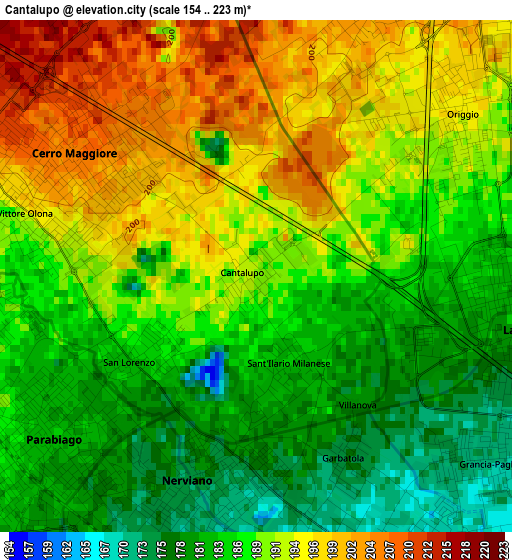
Below is the Elevation map of Cantalupo, which displays elevation range with different colors. Scale of the first map is from 154 to 223 m (505 to 732 ft) with average elevation of 188.8 meters (=619 ft) [note 1]
These maps also provides idea of topography and contour of this city, they are displayed at different zoom levels. More info about maps, scale and edge coordinates you can find below images.
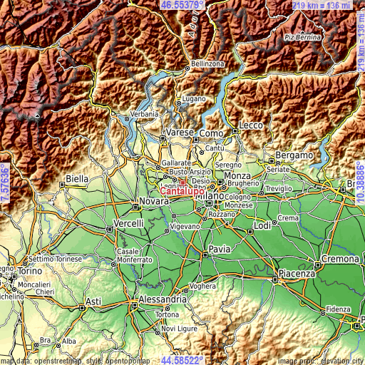
| \ | Map #1 | Topo.Map |
| Scale [m] | 154..223 m | × |
| Scale [ft] | 505..732 ft | × |
| Average | 188.8 m = 619 ft | × |
| Width | 6.84 km = 4.3 mi | 218.9 km = 136 mi |
| Height | 6.84 km = 4.3 mi | 218.9 km = 136 mi |
| ↑Max Latitude | 45.60888° | 46.55379° |
| Latitude at center | 45.57813° | 45.57813° |
| ↓Min Latitude | 45.547363° | 44.58522° |
| ← Min Longitude | 8.938665° | 7.57636° |
| Longitude center | 8.98261° | 8.98261° |
| →Max Longitude | 9.026555° | 10.38886° |
Nearby cities:
Cities around Cantalupo sort by population:
• Parabiago elevation 182 m
3.5 km,  235°
235°
• Lainate 182 m
3.5 km,  101°
101°
• Nerviano 173 m
2.8 km,  185°
185°
• Caronno Pertusella 196 m
5.4 km,  66°
66°
• Rescaldina 226 m
5.3 km,  330°
330°
• Canegrate 192 m
4.5 km,  255°
255°
• Cerro Maggiore 208 m
2.8 km,  308°
308°
• Uboldo 207 m
4.5 km,  21°
21°
• San Vittore Olona 193 m
3.3 km,  284°
284°
• Pogliano Milanese 166 m
4.6 km,  168°
168°
• Origgio 193 m
3.4 km,  51°
51°
• San Giorgio Su Legnano 199 m
5.4 km, 264°
Multilingual:
 En español:
Cantalupo elevación 189 m.
 En France:
Cantalupo élévation 189 m.
 Auf Deutsch:
Cantalupo höhe über dem Meeresspiegel ist 189 m.

Sources and notes:
- [note 1] Map square and city borders are not equal. Map elevation data is calculated only from area inside that square.
- [src 1] Elevation data from geonames database provided with same terms of usage.
- [src 2] The elevation map of Cantalupo is generated using elevation data from NASA's 3 arcsec (90m) resolution SRTM data.
- [src 3] Base (background) map © OpenStreetMap contributors tiles are generated by Geofabrik and OpenTopoMap.
Copyright & License:
This Cantalupo Elevation Map is licensed under CC BY-SA. You may reuse any part from this page, if you give a proper credit by linking to this URL:
 More info on terms of use page.