Trecella elevation
Trecella (Lombardy, Città metropolitana di Milano), Italy elevation is 125 meters and Trecella elevation in feet is 410 ft above sea level [src 1]. Trecella is a populated place (feature code) with elevation that is 197 meters (646 ft) smaller than average city elevation in Italy.
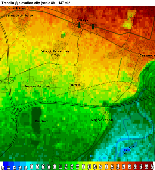
Below is the Elevation map of Trecella, which displays elevation range with different colors. Scale of the first map is from 89 to 147 m (292 to 482 ft) with average elevation of 120 meters (=394 ft) [note 1]
These maps also provides idea of topography and contour of this city, they are displayed at different zoom levels. More info about maps, scale and edge coordinates you can find below images.
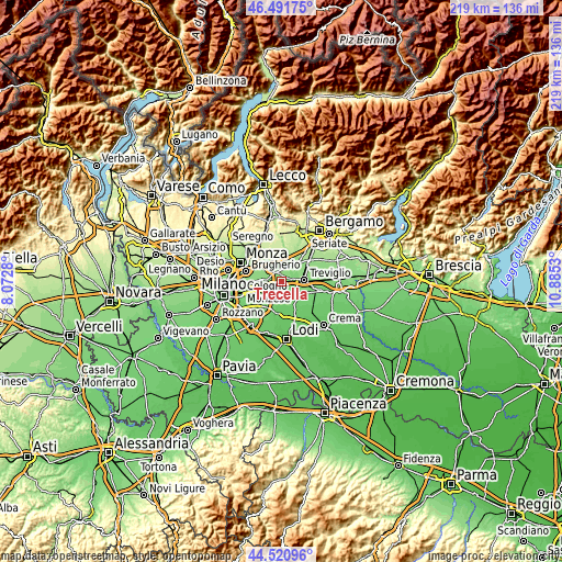
| \ | Map #1 | Topo.Map |
| Scale [m] | 89..147 m | × |
| Scale [ft] | 292..482 ft | × |
| Average | 120 m = 394 ft | × |
| Width | 6.85 km = 4.3 mi | 219.1 km = 136.1 mi |
| Height | 6.85 km = 4.3 mi | 219.1 km = 136.1 mi |
| ↑Max Latitude | 45.545765° | 46.49175° |
| Latitude at center | 45.51498° | 45.51498° |
| ↓Min Latitude | 45.484178° | 44.52096° |
| ← Min Longitude | 9.435105° | 8.0728° |
| Longitude center | 9.47905° | 9.47905° |
| →Max Longitude | 9.522995° | 10.8853° |
Nearby cities:
Cities around Trecella sort by population:
• Gorgonzola elevation 138 m
6 km,  286°
286°
• Melzo 121 m
4.9 km,  247°
247°
• Cassano d'Adda 135 m
3.1 km,  65°
65°
• Gessate 136 m
4.9 km,  319°
319°
• Inzago 141 m
2.8 km,  7°
7°
• Rivolta d'Adda 105 m
5.7 km,  152°
152°
• Pozzuolo Martesana 121 m
1.8 km,  266°
266°
• Bellinzago Lombardo 131 m
4 km, 319°
• Masate 149 m
5.9 km,  348°
348°
• Albignano 117 m
1.9 km, 145°
• Truccazzano 109 m
3.5 km,  192°
192°
• Villaggio Residenziale 128 m
1.7 km,  328°
328°
Multilingual:
 En español:
Trecella elevación 125 m.
 En France:
Trecella élévation 125 m.
 Auf Deutsch:
Trecella höhe über dem Meeresspiegel ist 125 m.

Sources and notes:
- [note 1] Map square and city borders are not equal. Map elevation data is calculated only from area inside that square.
- [src 1] Elevation data from geonames database provided with same terms of usage.
- [src 2] The elevation map of Trecella is generated using elevation data from NASA's 3 arcsec (90m) resolution SRTM data.
- [src 3] Base (background) map © OpenStreetMap contributors tiles are generated by Geofabrik and OpenTopoMap.
Copyright & License:
This Trecella Elevation Map is licensed under CC BY-SA. You may reuse any part from this page, if you give a proper credit by linking to this URL:
 More info on terms of use page.