San Pietro elevation
San Pietro (Campania, Provincia di Avellino), Italy elevation is 201 meters and San Pietro elevation in feet is 659 ft above sea level [src 1]. San Pietro is a populated place (feature code) with elevation that is 121 meters (397 ft) smaller than average city elevation in Italy.
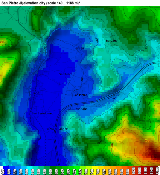
Below is the Elevation map of San Pietro, which displays elevation range with different colors. Scale of the first map is from 149 to 1188 m (489 to 3898 ft) with average elevation of 382.8 meters (=1256 ft) [note 1]
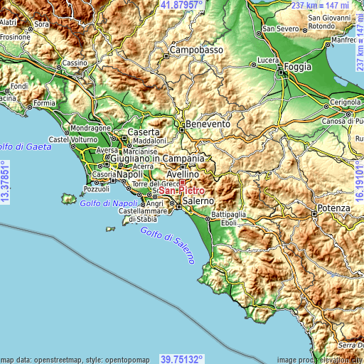
These maps also provides idea of topography and contour of this city, they are displayed at different zoom levels. More info about maps, scale and edge coordinates you can find below images.
| \ | Map #1 | Topo.Map |
| Scale [m] | 149..1188 m | × |
| Scale [ft] | 489..3898 ft | × |
| Average | 382.8 m = 1256 ft | × |
| Width | 7.4 km = 4.6 mi | 236.6 km = 147 mi |
| Height | 7.4 km = 4.6 mi | 236.6 km = 147 mi |
| ↑Max Latitude | 40.857226° | 41.87957° |
| Latitude at center | 40.82398° | 40.82398° |
| ↓Min Latitude | 40.790717° | 39.75132° |
| ← Min Longitude | 14.740815° | 13.37851° |
| Longitude center | 14.78476° | 14.78476° |
| →Max Longitude | 14.828705° | 16.19101° |
Nearby cities:
Cities around San Pietro sort by population:
• Solofra elevation 346 m
4.5 km,  76°
76°
• Mercato San Severino 145 m
5.1 km,  210°
210°
• Montoro Superiore 265 m
1.4 km,  124°
124°
• Piano 179 m
2.1 km,  259°
259°
• Forino 415 m
5.8 km,  310°
310°
• Torchiati 259 m
1.6 km,  113°
113°
• Banzano 394 m
2.6 km,  33°
33°
• Contrada 430 m
4.9 km,  352°
352°
• Carifi-Torello-Priscoli 164 m
5.7 km,  230°
230°
• Piazza di Pandola 175 m
2.1 km, 210°
• Borgo 202 m
1.8 km,  357°
357°
• Faraldo-Nocelleto 156 m
5.2 km,  199°
199°
Multilingual:
 En español:
San Pietro elevación 201 m.
 En France:
San Pietro élévation 201 m.
 Auf Deutsch:
San Pietro höhe über dem Meeresspiegel ist 201 m.

Sources and notes:
- [note 1] Map square and city borders are not equal. Map elevation data is calculated only from area inside that square.
- [src 1] Elevation data from geonames database provided with same terms of usage.
- [src 2] The elevation map of San Pietro is generated using elevation data from NASA's 3 arcsec (90m) resolution SRTM data.
- [src 3] Base (background) map © OpenStreetMap contributors tiles are generated by Geofabrik and OpenTopoMap.
Copyright & License:
This San Pietro Elevation Map is licensed under CC BY-SA. You may reuse any part from this page, if you give a proper credit by linking to this URL:
 More info on terms of use page.