San Giacomo elevation
San Giacomo (Lombardy, Provincia di Sondrio), Italy elevation is 357 meters and San Giacomo elevation in feet is 1171 ft above sea level [src 1]. San Giacomo is a populated place (feature code) with elevation that is 35 meters (115 ft) bigger than average city elevation in Italy.
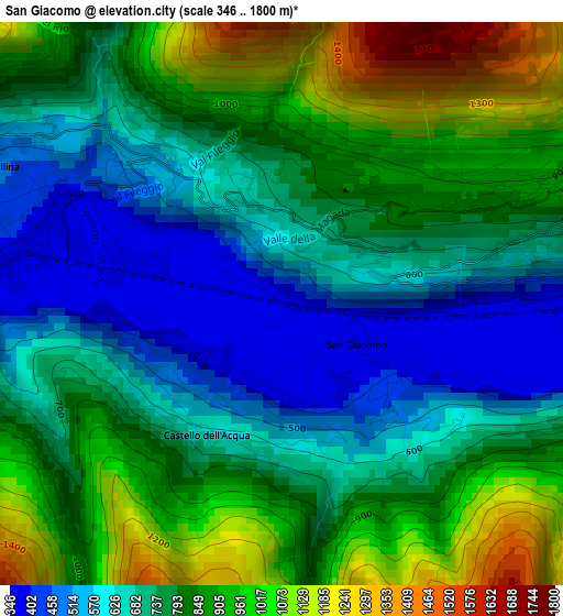
Below is the Elevation map of San Giacomo, which displays elevation range with different colors. Scale of the first map is from 346 to 1800 m (1135 to 5906 ft) with average elevation of 789.9 meters (=2592 ft) [note 1]
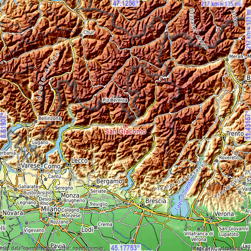
These maps also provides idea of topography and contour of this city, they are displayed at different zoom levels. More info about maps, scale and edge coordinates you can find below images.
| \ | Map #1 | Topo.Map |
| Scale [m] | 346..1800 m | × |
| Scale [ft] | 1135..5906 ft | × |
| Average | 789.9 m = 2592 ft | × |
| Width | 6.77 km = 4.2 mi | 216.6 km = 134.6 mi |
| Height | 6.77 km = 4.2 mi | 216.6 km = 134.6 mi |
| ↑Max Latitude | 46.19062° | 47.1256° |
| Latitude at center | 46.16019° | 46.16019° |
| ↓Min Latitude | 46.129743° | 45.17753° |
| ← Min Longitude | 9.981375° | 8.61907° |
| Longitude center | 10.02532° | 10.02532° |
| →Max Longitude | 10.069265° | 11.43157° |
Nearby cities:
Cities around San Giacomo sort by population:
• Montagna in Valtellina elevation 554 m
9.6 km,  282°
282°
• Tresivio 500 m
6.6 km,  285°
285°
• Ponte in Valtellina 503 m
4 km, 294°
• Chiuro 391 m
3.1 km, 284°
• Aprica 1176 m
9.6 km,  95°
95°
• Bianzone 441 m
7.1 km,  65°
65°
• Teglio 870 m
3.3 km, 65°
• Poggiridenti Piano 299 m
7.7 km, 278°
• Piateda Centro 298 m
7 km,  269°
269°
• Poggiridenti Alto 494 m
7.8 km, 281°
• Faedo Valtellino 550 m
9.2 km, 265°
• Castello dell'Acqua 626 m
1.8 km,  204°
204°
Multilingual:
 En español:
San Giacomo elevación 357 m.
 En France:
San Giacomo élévation 357 m.
 Auf Deutsch:
San Giacomo höhe über dem Meeresspiegel ist 357 m.

Sources and notes:
- [note 1] Map square and city borders are not equal. Map elevation data is calculated only from area inside that square.
- [src 1] Elevation data from geonames database provided with same terms of usage.
- [src 2] The elevation map of San Giacomo is generated using elevation data from NASA's 3 arcsec (90m) resolution SRTM data.
- [src 3] Base (background) map © OpenStreetMap contributors tiles are generated by Geofabrik and OpenTopoMap.
Copyright & License:
This San Giacomo Elevation Map is licensed under CC BY-SA. You may reuse any part from this page, if you give a proper credit by linking to this URL:
 More info on terms of use page.