Sezze Scalo elevation
Sezze Scalo (Latium, Provincia di Latina), Italy elevation is 44 meters and Sezze Scalo elevation in feet is 144 ft above sea level [src 1]. Sezze Scalo is a populated place (feature code) with elevation that is 278 meters (912 ft) smaller than average city elevation in Italy.
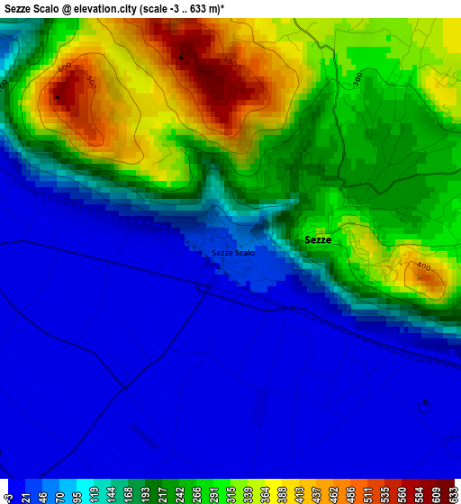
Below is the Elevation map of Sezze Scalo, which displays elevation range with different colors. Scale of the first map is from -3 to 633 m (-10 to 2077 ft) with average elevation of 160.2 meters (=526 ft) [note 1]
These maps also provides idea of topography and contour of this city, they are displayed at different zoom levels. More info about maps, scale and edge coordinates you can find below images.
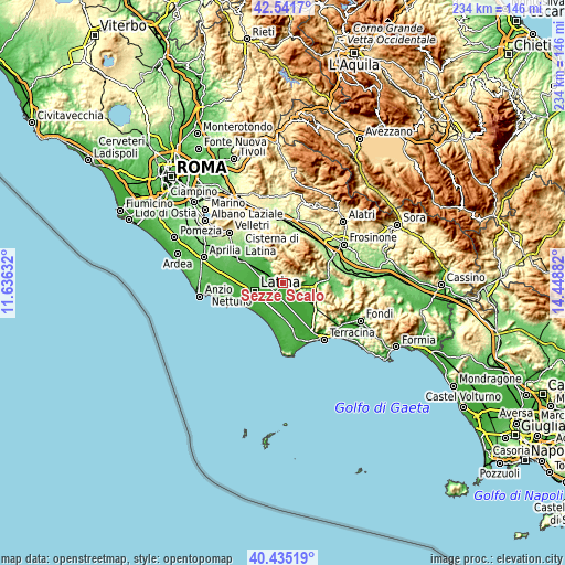
| \ | Map #1 | Topo.Map |
| Scale [m] | -3..633 m | × |
| Scale [ft] | -10..2077 ft | × |
| Average | 160.2 m = 526 ft | × |
| Width | 7.32 km = 4.5 mi | 234.2 km = 145.5 mi |
| Height | 7.32 km = 4.5 mi | 234.2 km = 145.5 mi |
| ↑Max Latitude | 41.529916° | 42.5417° |
| Latitude at center | 41.49701° | 41.49701° |
| ↓Min Latitude | 41.464087° | 40.43519° |
| ← Min Longitude | 12.998625° | 11.63632° |
| Longitude center | 13.04257° | 13.04257° |
| →Max Longitude | 13.086515° | 14.44882° |
Nearby cities:
Cities around Sezze Scalo sort by population:
• Latina elevation 27 m
12 km,  253°
253°
• Sezze 304 m
1.6 km,  77°
77°
• Priverno 96 m
11.7 km,  104°
104°
• Latina Scalo 18 m
8.9 km,  295°
295°
• Pontinia 6 m
9.6 km,  179°
179°
• Norma 440 m
11.6 km,  328°
328°
• Roccagorga 282 m
9.9 km,  71°
71°
• Carrara-Pontenuovo 17 m
8.8 km, 303°
• Borgo San Michele 15 m
8.7 km,  221°
221°
• Maenza 314 m
12.1 km, 75°
• Sermoneta 238 m
7.5 km,  320°
320°
• Bassiano 570 m
6.2 km,  348°
348°
Multilingual:
 En español:
Sezze Scalo elevación 44 m.
 En France:
Sezze Scalo élévation 44 m.
 Auf Deutsch:
Sezze Scalo höhe über dem Meeresspiegel ist 44 m.

Sources and notes:
- [note 1] Map square and city borders are not equal. Map elevation data is calculated only from area inside that square.
- [src 1] Elevation data from geonames database provided with same terms of usage.
- [src 2] The elevation map of Sezze Scalo is generated using elevation data from NASA's 3 arcsec (90m) resolution SRTM data.
- [src 3] Base (background) map © OpenStreetMap contributors tiles are generated by Geofabrik and OpenTopoMap.
Copyright & License:
This Sezze Scalo Elevation Map is licensed under CC BY-SA. You may reuse any part from this page, if you give a proper credit by linking to this URL:
 More info on terms of use page.