Tuturano elevation
Tuturano (Apulia, Provincia di Brindisi), Italy elevation is 46 meters and Tuturano elevation in feet is 151 ft above sea level [src 1]. Tuturano is a populated place (feature code) with elevation that is 276 meters (906 ft) smaller than average city elevation in Italy.
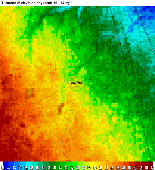
Below is the Elevation map of Tuturano, which displays elevation range with different colors. Scale of the first map is from 19 to 67 m (62 to 220 ft) with average elevation of 44.4 meters (=146 ft) [note 1]
These maps also provides idea of topography and contour of this city, they are displayed at different zoom levels. More info about maps, scale and edge coordinates you can find below images.
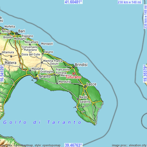
| \ | Map #1 | Topo.Map |
| Scale [m] | 19..67 m | × |
| Scale [ft] | 62..220 ft | × |
| Average | 44.4 m = 146 ft | × |
| Width | 7.43 km = 4.6 mi | 237.6 km = 147.6 mi |
| Height | 7.43 km = 4.6 mi | 237.6 km = 147.6 mi |
| ↑Max Latitude | 40.578126° | 41.60481° |
| Latitude at center | 40.54474° | 40.54474° |
| ↓Min Latitude | 40.511338° | 39.46763° |
| ← Min Longitude | 17.903595° | 16.54129° |
| Longitude center | 17.94754° | 17.94754° |
| →Max Longitude | 17.991485° | 19.35379° |
Nearby cities:
Cities around Tuturano sort by population:
• Brindisi elevation 17 m
9.8 km,  354°
354°
• Mesagne 71 m
11.9 km,  277°
277°
• Squinzano 47 m
14.5 km,  147°
147°
• San Pietro Vernotico 40 m
7.5 km, 145°
• Campi Salentina 33 m
17.5 km,  159°
159°
• San Pancrazio Salentino 63 m
17 km,  214°
214°
• San Donaci 46 m
10.9 km,  191°
191°
• Cellino San Marco 58 m
8.3 km,  170°
170°
• Torchiarolo 24 m
11.1 km,  127°
127°
• Guagnano 46 m
16 km,  179°
179°
• Materdomini 1 m
12.4 km,  4°
4°
• La Rosa 23 m
6.9 km, 3°
Multilingual:
 En español:
Tuturano elevación 46 m.
 En France:
Tuturano élévation 46 m.


Sources and notes:
- [note 1] Map square and city borders are not equal. Map elevation data is calculated only from area inside that square.
- [src 1] Elevation data from geonames database provided with same terms of usage.
- [src 2] The elevation map of Tuturano is generated using elevation data from NASA's 3 arcsec (90m) resolution SRTM data.
- [src 3] Base (background) map © OpenStreetMap contributors tiles are generated by Geofabrik and OpenTopoMap.
Copyright & License:
This Tuturano Elevation Map is licensed under CC BY-SA. You may reuse any part from this page, if you give a proper credit by linking to this URL:
 More info on terms of use page.