Riscone elevation
Riscone (Trentino-Alto Adige, Bolzano), Italy elevation is 958 meters and Riscone elevation in feet is 3143 ft above sea level [src 1]. Riscone is a populated place (feature code) with elevation that is 636 meters (2087 ft) bigger than average city elevation in Italy.
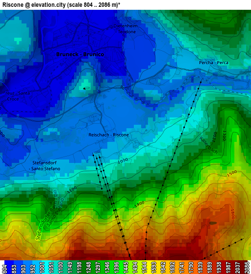
Below is the Elevation map of Riscone, which displays elevation range with different colors. Scale of the first map is from 804 to 2086 m (2638 to 6844 ft) with average elevation of 1180.1 meters (=3872 ft) [note 1]
These maps also provides idea of topography and contour of this city, they are displayed at different zoom levels. More info about maps, scale and edge coordinates you can find below images.
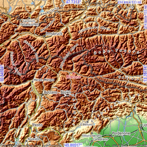
| \ | Map #1 | Topo.Map |
| Scale [m] | 804..2086 m | × |
| Scale [ft] | 2638..6844 ft | × |
| Average | 1180.1 m = 3872 ft | × |
| Width | 6.69 km = 4.2 mi | 214.2 km = 133.1 mi |
| Height | 6.69 km = 4.2 mi | 214.2 km = 133.1 mi |
| ↑Max Latitude | 46.806937° | 47.7313° |
| Latitude at center | 46.77685° | 46.77685° |
| ↓Min Latitude | 46.746746° | 45.80517° |
| ← Min Longitude | 11.907545° | 10.54524° |
| Longitude center | 11.95149° | 11.95149° |
| →Max Longitude | 11.995435° | 13.35774° |
Nearby cities:
Cities around Riscone sort by population:
• Brunico elevation 829 m
2.8 km,  332°
332°
• Rasun Anterselva - Rasen-Antholz 1019 m
7.3 km,  88°
88°
• Gais 837 m
6.6 km,  358°
358°
• Falzes 1032 m
6.6 km,  308°
308°
• Valdaora di Mezzo 1052 m
6.2 km,  107°
107°
• Monguelfo 1093 m
11.9 km,  100°
100°
• San Vigilio 1190 m
8.8 km,  190°
190°
• La Valle - Wengen 1347 m
13.4 km, 188°
• San Lorenzo di Sebato 809 m
3.4 km,  285°
285°
• Chienes 804 m
9.1 km, 291°
• Perca 1010 m
3 km,  52°
52°
• San Martino in Badia 1136 m
11.4 km,  201°
201°
Multilingual:
 En español:
Riscone elevación 958 m.
 En France:
Riscone élévation 958 m.
 Auf Deutsch:
Reischach höhe über dem Meeresspiegel ist 958 m.

Sources and notes:
- [note 1] Map square and city borders are not equal. Map elevation data is calculated only from area inside that square.
- [src 1] Elevation data from geonames database provided with same terms of usage.
- [src 2] The elevation map of Riscone is generated using elevation data from NASA's 3 arcsec (90m) resolution SRTM data.
- [src 3] Base (background) map © OpenStreetMap contributors tiles are generated by Geofabrik and OpenTopoMap.
Copyright & License:
This Riscone Elevation Map is licensed under CC BY-SA. You may reuse any part from this page, if you give a proper credit by linking to this URL:
 More info on terms of use page.