Valle Santa elevation
Valle Santa (Latium, Città metropolitana di Roma Capitale), Italy elevation is 93 meters and Valle Santa elevation in feet is 305 ft above sea level [src 1]. Valle Santa is a populated place (feature code) with elevation that is 229 meters (751 ft) smaller than average city elevation in Italy.
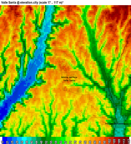
Below is the Elevation map of Valle Santa, which displays elevation range with different colors. Scale of the first map is from 17 to 117 m (56 to 384 ft) with average elevation of 72.5 meters (=238 ft) [note 1]
These maps also provides idea of topography and contour of this city, they are displayed at different zoom levels. More info about maps, scale and edge coordinates you can find below images.
| \ | Map #1 | Topo.Map |
| Scale [m] | 17..117 m | × |
| Scale [ft] | 56..384 ft | × |
| Average | 72.5 m = 238 ft | × |
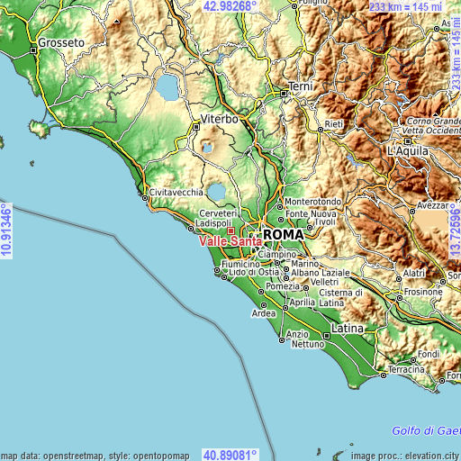
| Width | 7.27 km = 4.5 mi | 232.6 km = 144.5 mi |
| Height | 7.27 km = 4.5 mi | 232.6 km = 144.5 mi |
| ↑Max Latitude | 41.977997° | 42.98268° |
| Latitude at center | 41.94532° | 41.94532° |
| ↓Min Latitude | 41.912626° | 40.89081° |
| ← Min Longitude | 12.275765° | 10.91346° |
| Longitude center | 12.31971° | 12.31971° |
| →Max Longitude | 12.363655° | 13.72596° |
Nearby cities:
Cities around Valle Santa sort by population:
• La Massimina-Casal Lumbroso elevation 47 m
8.6 km,  158°
158°
• Cesano 189 m
14.4 km,  5°
5°
• Ara Nova 73 m
6.7 km,  258°
258°
• Formello 171 m
14.4 km,  25°
25°
• Ponte Galeria-La Pisana 35 m
11.1 km,  171°
171°
• Passoscuro 3 m
14.3 km,  250°
250°
• Valcanneto 56 m
13.4 km,  272°
272°
• Le Rughe 191 m
14.5 km,  18°
18°
• Ponton dell'Elce 166 m
11.1 km,  320°
320°
• Tragliatella Campitello 146 m
9.4 km, 323°
• Osteria Nuova 143 m
10.3 km,  355°
355°
• Maccarese 7 m
11.2 km,  227°
227°
Multilingual:
 En español:
Valle Santa elevación 93 m.
 En France:
Valle Santa élévation 93 m.
 Auf Deutsch:
Valle Santa höhe über dem Meeresspiegel ist 93 m.

Sources and notes:
- [note 1] Map square and city borders are not equal. Map elevation data is calculated only from area inside that square.
- [src 1] Elevation data from geonames database provided with same terms of usage.
- [src 2] The elevation map of Valle Santa is generated using elevation data from NASA's 3 arcsec (90m) resolution SRTM data.
- [src 3] Base (background) map © OpenStreetMap contributors tiles are generated by Geofabrik and OpenTopoMap.
Copyright & License:
This Valle Santa Elevation Map is licensed under CC BY-SA. You may reuse any part from this page, if you give a proper credit by linking to this URL:
 More info on terms of use page.