Stiava elevation
Stiava (Tuscany, Provincia di Lucca), Italy elevation is 15 meters and Stiava elevation in feet is 49 ft above sea level [src 1]. Stiava is a populated locality (feature code) with elevation that is 307 meters (1007 ft) smaller than average city elevation in Italy.
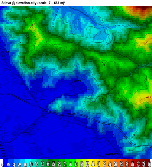
Below is the Elevation map of Stiava, which displays elevation range with different colors. Scale of the first map is from -7 to 661 m (-23 to 2169 ft) with average elevation of 118.3 meters (=388 ft) [note 1]
These maps also provides idea of topography and contour of this city, they are displayed at different zoom levels. More info about maps, scale and edge coordinates you can find below images.
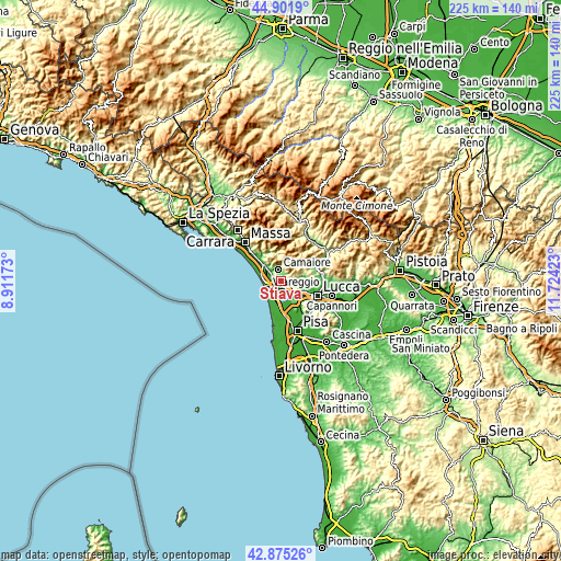
| \ | Map #1 | Topo.Map |
| Scale [m] | -7..661 m | × |
| Scale [ft] | -23..2169 ft | × |
| Average | 118.3 m = 388 ft | × |
| Width | 7.04 km = 4.4 mi | 225.3 km = 140 mi |
| Height | 7.04 km = 4.4 mi | 225.3 km = 140 mi |
| ↑Max Latitude | 43.928858° | 44.9019° |
| Latitude at center | 43.8972° | 43.8972° |
| ↓Min Latitude | 43.865525° | 42.87526° |
| ← Min Longitude | 10.274035° | 8.91173° |
| Longitude center | 10.31798° | 10.31798° |
| →Max Longitude | 10.361925° | 11.72423° |
Nearby cities:
Cities around Stiava sort by population:
• Viareggio elevation 4 m
6.4 km,  238°
238°
• Camaiore 36 m
5.3 km,  342°
342°
• Pietrasanta 12 m
10 km,  313°
313°
• Torre del Lago Puccini 3 m
7.9 km,  196°
196°
• Massarosa 13 m
4 km,  148°
148°
• Piano di Mommio 5 m
3.8 km,  291°
291°
• Piano di Conca 7 m
1.9 km,  259°
259°
• Corsanico-Bargecchia 205 m
1.6 km,  322°
322°
• Filettole 9 m
11.5 km,  144°
144°
• San Martino in Freddana-Monsagrati 80 m
9.7 km,  82°
82°
• Pescaglia 420 m
10.7 km,  45°
45°
• Pontestazzemese 167 m
11.2 km,  350°
350°
Multilingual:
 En español:
Stiava elevación 15 m.
 En France:
Stiava élévation 15 m.


Sources and notes:
- [note 1] Map square and city borders are not equal. Map elevation data is calculated only from area inside that square.
- [src 1] Elevation data from geonames database provided with same terms of usage.
- [src 2] The elevation map of Stiava is generated using elevation data from NASA's 3 arcsec (90m) resolution SRTM data.
- [src 3] Base (background) map © OpenStreetMap contributors tiles are generated by Geofabrik and OpenTopoMap.
Copyright & License:
This Stiava Elevation Map is licensed under CC BY-SA. You may reuse any part from this page, if you give a proper credit by linking to this URL:
 More info on terms of use page.