Vaie elevation
Vaie (Piedmont, Torino), Italy elevation is 383 meters and Vaie elevation in feet is 1257 ft above sea level [src 1]. Vaie is a seat of a third-order administrative division (feature code) with elevation that is 61 meters (200 ft) bigger than average city elevation in Italy.
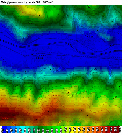
Below is the Elevation map of Vaie, which displays elevation range with different colors. Scale of the first map is from 362 to 1633 m (1188 to 5358 ft) with average elevation of 757.5 meters (=2485 ft) [note 1]
These maps also provides idea of topography and contour of this city, they are displayed at different zoom levels. More info about maps, scale and edge coordinates you can find below images.
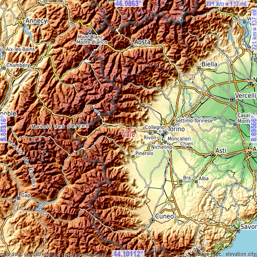
| \ | Map #1 | Topo.Map |
| Scale [m] | 362..1633 m | × |
| Scale [ft] | 1188..5358 ft | × |
| Average | 757.5 m = 2485 ft | × |
| Width | 6.9 km = 4.3 mi | 220.7 km = 137.1 mi |
| Height | 6.9 km = 4.3 mi | 220.7 km = 137.1 mi |
| ↑Max Latitude | 45.13335° | 46.0863° |
| Latitude at center | 45.10234° | 45.10234° |
| ↓Min Latitude | 45.071313° | 44.10112° |
| ← Min Longitude | 7.245465° | 5.88316° |
| Longitude center | 7.28941° | 7.28941° |
| →Max Longitude | 7.333355° | 8.69566° |
Nearby cities:
Cities around Vaie sort by population:
• Sant'Ambrogio di Torino elevation 354 m
6 km,  96°
96°
• Sant'Antonino di Susa 383 m
1.4 km,  294°
294°
• Condove 386 m
2.1 km,  44°
44°
• Coazze 729 m
5.7 km,  171°
171°
• Villar Dora 354 m
7.5 km,  79°
79°
• Villar Focchiardo 398 m
4.2 km, 285°
• Baratte 403 m
4.3 km,  283°
283°
• Borgone Susa 402 m
4.8 km,  299°
299°
• Chiusa di San Michele 368 m
3 km,  85°
85°
• Caprie 383 m
3.9 km,  60°
60°
• Valgioie 615 m
6.3 km,  132°
132°
• San Didero 438 m
7 km, 301°
Multilingual:
 En español:
Vaie elevación 383 m.
 En France:
Vaie élévation 383 m.


Sources and notes:
- [note 1] Map square and city borders are not equal. Map elevation data is calculated only from area inside that square.
- [src 1] Elevation data from geonames database provided with same terms of usage.
- [src 2] The elevation map of Vaie is generated using elevation data from NASA's 3 arcsec (90m) resolution SRTM data.
- [src 3] Base (background) map © OpenStreetMap contributors tiles are generated by Geofabrik and OpenTopoMap.
Copyright & License:
This Vaie Elevation Map is licensed under CC BY-SA. You may reuse any part from this page, if you give a proper credit by linking to this URL:
 More info on terms of use page.