Solza elevation
Solza (Lombardy, Provincia di Bergamo), Italy elevation is 253 meters and Solza elevation in feet is 830 ft above sea level [src 1]. Solza is a seat of a third-order administrative division (feature code) with elevation that is 69 meters (226 ft) smaller than average city elevation in Italy.
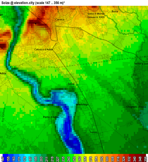
Below is the Elevation map of Solza, which displays elevation range with different colors. Scale of the first map is from 147 to 356 m (482 to 1168 ft) with average elevation of 244.3 meters (=802 ft) [note 1]
These maps also provides idea of topography and contour of this city, they are displayed at different zoom levels. More info about maps, scale and edge coordinates you can find below images.
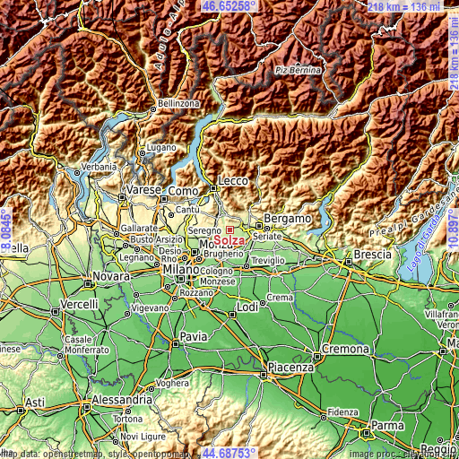
| \ | Map #1 | Topo.Map |
| Scale [m] | 147..356 m | × |
| Scale [ft] | 482..1168 ft | × |
| Average | 244.3 m = 802 ft | × |
| Width | 6.83 km = 4.2 mi | 218.5 km = 135.8 mi |
| Height | 6.83 km = 4.2 mi | 218.5 km = 135.8 mi |
| ↑Max Latitude | 45.709375° | 46.65258° |
| Latitude at center | 45.67868° | 45.67868° |
| ↓Min Latitude | 45.647968° | 44.68753° |
| ← Min Longitude | 9.446805° | 8.0845° |
| Longitude center | 9.49075° | 9.49075° |
| →Max Longitude | 9.534695° | 10.897° |
Nearby cities:
Cities around Solza sort by population:
• Calusco d'Adda elevation 269 m
1.9 km,  305°
305°
• Terno d'Isola 230 m
3.2 km,  76°
76°
• Robbiate 268 m
4.3 km,  284°
284°
• Carvico 276 m
2.6 km,  351°
351°
• Suisio 233 m
2.6 km,  159°
159°
• Paderno d'Adda 269 m
3.6 km,  270°
270°
• Piazza Caduti 280 m
3.1 km,  17°
17°
• Sotto il Monte Giovanni XXIII 282 m
3.2 km, 18°
• Chignolo d'Isola 227 m
3.1 km,  113°
113°
• Verderio Superiore 256 m
4.1 km,  252°
252°
• Medolago 242 m
1 km,  145°
145°
• Porto d'Adda 238 m
2.2 km,  212°
212°
Multilingual:
 En español:
Solza elevación 253 m.
 En France:
Solza élévation 253 m.


Sources and notes:
- [note 1] Map square and city borders are not equal. Map elevation data is calculated only from area inside that square.
- [src 1] Elevation data from geonames database provided with same terms of usage.
- [src 2] The elevation map of Solza is generated using elevation data from NASA's 3 arcsec (90m) resolution SRTM data.
- [src 3] Base (background) map © OpenStreetMap contributors tiles are generated by Geofabrik and OpenTopoMap.
Copyright & License:
This Solza Elevation Map is licensed under CC BY-SA. You may reuse any part from this page, if you give a proper credit by linking to this URL:
 More info on terms of use page.