Ramponio Verna elevation
Ramponio Verna (Lombardy, Provincia di Como), Italy elevation is 701 meters and Ramponio Verna elevation in feet is 2300 ft above sea level [src 1]. Ramponio Verna is a seat of a third-order administrative division (feature code) with elevation that is 379 meters (1243 ft) bigger than average city elevation in Italy.
Below is the Elevation map of Ramponio Verna, which displays elevation range with different colors. Scale of the first map is from 267 to 1314 m (876 to 4311 ft) with average elevation of 645.2 meters (=2117 ft) [note 1]
These maps also provides idea of topography and contour of this city, they are displayed at different zoom levels. More info about maps, scale and edge coordinates you can find below images.
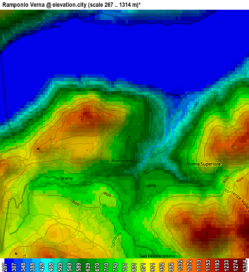
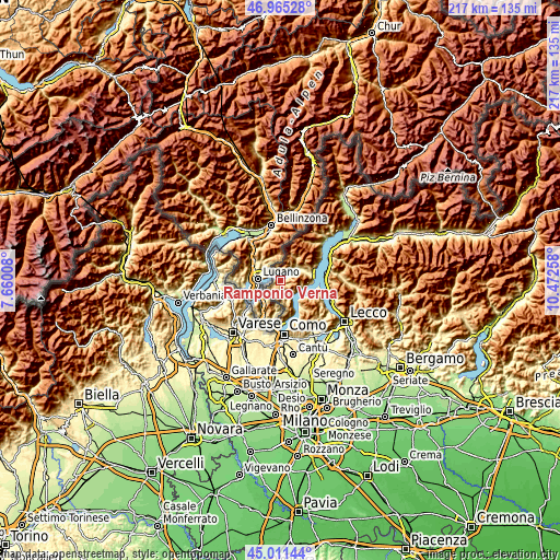
| \ | Map #1 | Topo.Map |
| Scale [m] | 267..1314 m | × |
| Scale [ft] | 876..4311 ft | × |
| Average | 645.2 m = 2117 ft | × |
| Width | 6.79 km = 4.2 mi | 217.2 km = 135 mi |
| Height | 6.79 km = 4.2 mi | 217.2 km = 135 mi |
| ↑Max Latitude | 46.0275° | 46.96528° |
| Latitude at center | 45.99698° | 45.99698° |
| ↓Min Latitude | 45.966443° | 45.01144° |
| ← Min Longitude | 9.022385° | 7.66008° |
| Longitude center | 9.06633° | 9.06633° |
| →Max Longitude | 9.110275° | 10.47258° |
Nearby cities:
Cities around Ramponio Verna sort by population:
• San Fedele Intelvi elevation 762 m
3.4 km,  161°
161°
• San Fedele Superiore 782 m
3.4 km,  179°
179°
• Lanzo d'Intelvi 893 m
4 km,  240°
240°
• Pellio Intelvi 803 m
2 km,  197°
197°
• Castiglione d'Intelvi 618 m
4.8 km, 157°
• Osteno 287 m
1.7 km,  51°
51°
• San Mamete 286 m
3.3 km,  342°
342°
• Laino 680 m
1.6 km,  153°
153°
• Osteno-Claino 383 m
1.8 km,  65°
65°
• Casasco Intelvi 839 m
6 km,  173°
173°
• Ponna Superiore 883 m
2.3 km,  111°
111°
• Blessagno 779 m
4.9 km, 150°
Multilingual:
 En español:
Ramponio Verna elevación 701 m.
 En France:
Ramponio Verna élévation 701 m.
 Auf Deutsch:
Ramponio Verna höhe über dem Meeresspiegel ist 701 m.

Sources and notes:
- [note 1] Map square and city borders are not equal. Map elevation data is calculated only from area inside that square.
- [src 1] Elevation data from geonames database provided with same terms of usage.
- [src 2] The elevation map of Ramponio Verna is generated using elevation data from NASA's 3 arcsec (90m) resolution SRTM data.
- [src 3] Base (background) map © OpenStreetMap contributors tiles are generated by Geofabrik and OpenTopoMap.
Copyright & License:
This Ramponio Verna Elevation Map is licensed under CC BY-SA. You may reuse any part from this page, if you give a proper credit by linking to this URL:
 More info on terms of use page.