Viddalba elevation
Viddalba (Sardinia, Provincia di Sassari), Italy elevation is 22 meters and Viddalba elevation in feet is 72 ft above sea level [src 1]. Viddalba is a seat of a third-order administrative division (feature code) with elevation that is 300 meters (984 ft) smaller than average city elevation in Italy.
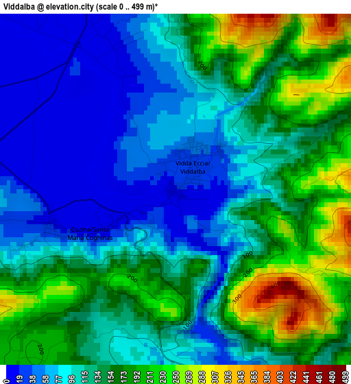
Below is the Elevation map of Viddalba, which displays elevation range with different colors. Scale of the first map is from 0 to 499 m (0 to 1637 ft) with average elevation of 124.5 meters (=408 ft) [note 1]
These maps also provides idea of topography and contour of this city, they are displayed at different zoom levels. More info about maps, scale and edge coordinates you can find below images.
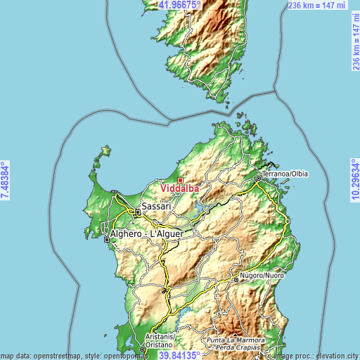
| \ | Map #1 | Topo.Map |
| Scale [m] | 0..499 m | × |
| Scale [ft] | 0..1637 ft | × |
| Average | 124.5 m = 408 ft | × |
| Width | 7.39 km = 4.6 mi | 236.3 km = 146.8 mi |
| Height | 7.39 km = 4.6 mi | 236.3 km = 146.8 mi |
| ↑Max Latitude | 40.945792° | 41.96675° |
| Latitude at center | 40.91259° | 40.91259° |
| ↓Min Latitude | 40.879372° | 39.84135° |
| ← Min Longitude | 8.846145° | 7.48384° |
| Longitude center | 8.89009° | 8.89009° |
| →Max Longitude | 8.934035° | 10.29634° |
Nearby cities:
Cities around Viddalba sort by population:
• Valledoria elevation 15 m
5.9 km,  287°
287°
• Codaruina 15 m
5.8 km, 287°
• Perfugas 92 m
8.9 km,  183°
183°
• Trinità d'Agultu e Vignola 365 m
8.2 km,  15°
15°
• Badesi 82 m
5.8 km,  353°
353°
• Trinità d'Agultu 357 m
8.4 km,  13°
13°
• Santa Maria Coghinas 11 m
2.4 km,  247°
247°
• Sedini 336 m
9.1 km,  222°
222°
• Laerru 175 m
11.5 km,  202°
202°
• Bulzi 202 m
8.9 km,  214°
214°
• Erula 447 m
14.1 km,  161°
161°
• Bortigiadas 476 m
13.1 km,  100°
100°
Multilingual:
 En español:
Viddalba elevación 22 m.
 En France:
Viddalba élévation 22 m.


Sources and notes:
- [note 1] Map square and city borders are not equal. Map elevation data is calculated only from area inside that square.
- [src 1] Elevation data from geonames database provided with same terms of usage.
- [src 2] The elevation map of Viddalba is generated using elevation data from NASA's 3 arcsec (90m) resolution SRTM data.
- [src 3] Base (background) map © OpenStreetMap contributors tiles are generated by Geofabrik and OpenTopoMap.
Copyright & License:
This Viddalba Elevation Map is licensed under CC BY-SA. You may reuse any part from this page, if you give a proper credit by linking to this URL:
 More info on terms of use page.