Bugnara elevation
Bugnara (Abruzzo, Provincia dell' Aquila), Italy elevation is 503 meters and Bugnara elevation in feet is 1650 ft above sea level [src 1]. Bugnara is a seat of a third-order administrative division (feature code) with elevation that is 181 meters (594 ft) bigger than average city elevation in Italy.
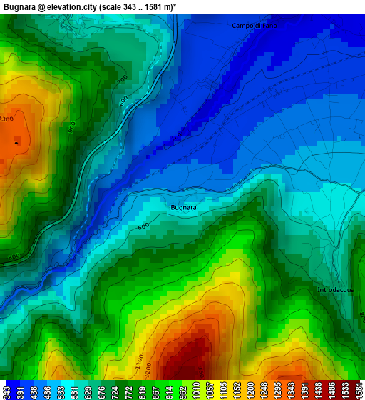
Below is the Elevation map of Bugnara, which displays elevation range with different colors. Scale of the first map is from 343 to 1581 m (1125 to 5187 ft) with average elevation of 714.9 meters (=2345 ft) [note 1]
These maps also provides idea of topography and contour of this city, they are displayed at different zoom levels. More info about maps, scale and edge coordinates you can find below images.
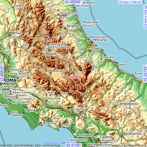
| \ | Map #1 | Topo.Map |
| Scale [m] | 343..1581 m | × |
| Scale [ft] | 1125..5187 ft | × |
| Average | 714.9 m = 2345 ft | × |
| Width | 7.26 km = 4.5 mi | 232.3 km = 144.3 mi |
| Height | 7.26 km = 4.5 mi | 232.3 km = 144.3 mi |
| ↑Max Latitude | 42.056467° | 43.05989° |
| Latitude at center | 42.02383° | 42.02383° |
| ↓Min Latitude | 41.991176° | 40.9706° |
| ← Min Longitude | 13.817465° | 12.45516° |
| Longitude center | 13.86141° | 13.86141° |
| →Max Longitude | 13.905355° | 15.26766° |
Nearby cities:
Cities around Bugnara sort by population:
• Sulmona elevation 410 m
6 km,  61°
61°
• Pratola Peligna 326 m
8.2 km,  7°
7°
• Raiano 390 m
9.5 km,  335°
335°
• Pacentro 688 m
11.1 km,  74°
74°
• Corfinio 354 m
11 km,  350°
350°
• Introdacqua 624 m
3.4 km,  117°
117°
• Prezza 523 m
4.3 km,  330°
330°
• Goriano Sicoli 713 m
9.5 km,  311°
311°
• Villalago 917 m
10 km,  190°
190°
• Pettorano sul Gizio 633 m
9.9 km, 124°
• Anversa degli Abruzzi 578 m
5.8 km,  235°
235°
• Cocullo 889 m
7.2 km,  277°
277°
Multilingual:
 En español:
Bugnara elevación 503 m.
 En France:
Bugnara élévation 503 m.


Sources and notes:
- [note 1] Map square and city borders are not equal. Map elevation data is calculated only from area inside that square.
- [src 1] Elevation data from geonames database provided with same terms of usage.
- [src 2] The elevation map of Bugnara is generated using elevation data from NASA's 3 arcsec (90m) resolution SRTM data.
- [src 3] Base (background) map © OpenStreetMap contributors tiles are generated by Geofabrik and OpenTopoMap.
Copyright & License:
This Bugnara Elevation Map is licensed under CC BY-SA. You may reuse any part from this page, if you give a proper credit by linking to this URL:
 More info on terms of use page.