Piana di Monte Verna elevation
Piana di Monte Verna (Campania, Provincia di Caserta), Italy elevation is 70 meters and Piana di Monte Verna elevation in feet is 230 ft above sea level [src 1]. Piana di Monte Verna is a seat of a third-order administrative division (feature code) with elevation that is 252 meters (827 ft) smaller than average city elevation in Italy.
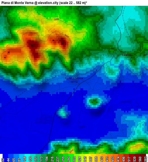
Below is the Elevation map of Piana di Monte Verna, which displays elevation range with different colors. Scale of the first map is from 22 to 582 m (72 to 1909 ft) with average elevation of 151.5 meters (=497 ft) [note 1]
These maps also provides idea of topography and contour of this city, they are displayed at different zoom levels. More info about maps, scale and edge coordinates you can find below images.
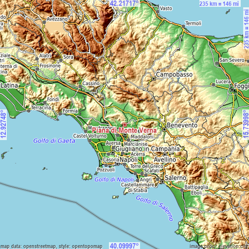
| \ | Map #1 | Topo.Map |
| Scale [m] | 22..582 m | × |
| Scale [ft] | 72..1909 ft | × |
| Average | 151.5 m = 497 ft | × |
| Width | 7.36 km = 4.6 mi | 235.4 km = 146.3 mi |
| Height | 7.36 km = 4.6 mi | 235.4 km = 146.3 mi |
| ↑Max Latitude | 41.200193° | 42.21717° |
| Latitude at center | 41.16712° | 41.16712° |
| ↓Min Latitude | 41.13403° | 40.09997° |
| ← Min Longitude | 14.289785° | 12.92748° |
| Longitude center | 14.33373° | 14.33373° |
| →Max Longitude | 14.377675° | 15.73998° |
Nearby cities:
Cities around Piana di Monte Verna sort by population:
• Bellona elevation 71 m
8.5 km,  265°
265°
• Castel Morrone 230 m
5.4 km,  161°
161°
• Annunziata 246 m
5.8 km,  152°
152°
• Alvignano 133 m
8.6 km,  1°
1°
• Caiazzo 144 m
2.9 km,  48°
48°
• Limatola 49 m
5.9 km,  120°
120°
• Sant'Angelo in Formis 41 m
9 km,  231°
231°
• Casola 340 m
9 km, 153°
• Castel di Sasso 202 m
5.5 km,  300°
300°
• Liberi 466 m
7.6 km,  330°
330°
• Ruviano 70 m
8 km, 52°
• Pontelatone 136 m
7.8 km,  293°
293°
Multilingual:
 En español:
Piana di Monte Verna elevación 70 m.
 En France:
Piana di Monte Verna élévation 70 m.
 Auf Deutsch:
Piana di Monte Verna höhe über dem Meeresspiegel ist 70 m.
 На русском:
Piana di Monte Verna высота над уровнем моря 70 м
Sources and notes:
- [note 1] Map square and city borders are not equal. Map elevation data is calculated only from area inside that square.
- [src 1] Elevation data from geonames database provided with same terms of usage.
- [src 2] The elevation map of Piana di Monte Verna is generated using elevation data from NASA's 3 arcsec (90m) resolution SRTM data.
- [src 3] Base (background) map © OpenStreetMap contributors tiles are generated by Geofabrik and OpenTopoMap.
Copyright & License:
This Piana di Monte Verna Elevation Map is licensed under CC BY-SA. You may reuse any part from this page, if you give a proper credit by linking to this URL:
 More info on terms of use page.