Barbara elevation
Barbara (The Marches, Provincia di Ancona), Italy elevation is 197 meters and Barbara elevation in feet is 646 ft above sea level [src 1]. Barbara is a seat of a third-order administrative division (feature code) with elevation that is 125 meters (410 ft) smaller than average city elevation in Italy.
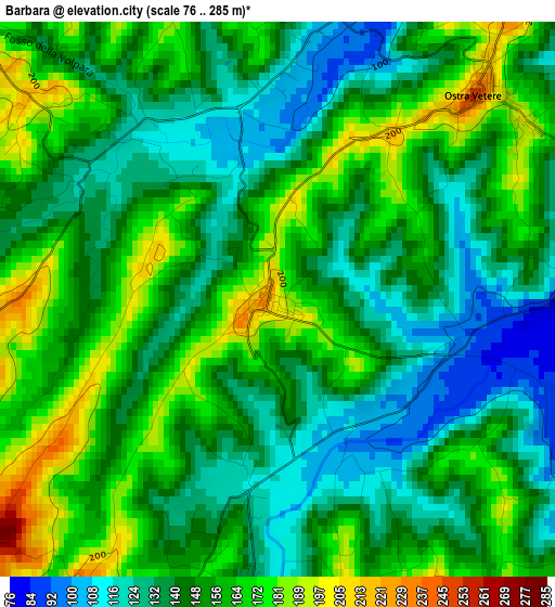
Below is the Elevation map of Barbara, which displays elevation range with different colors. Scale of the first map is from 76 to 285 m (249 to 935 ft) with average elevation of 149.9 meters (=492 ft) [note 1]
These maps also provides idea of topography and contour of this city, they are displayed at different zoom levels. More info about maps, scale and edge coordinates you can find below images.
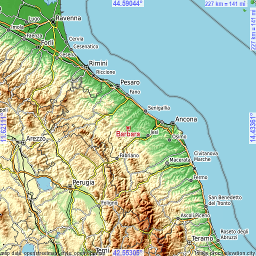
| \ | Map #1 | Topo.Map |
| Scale [m] | 76..285 m | × |
| Scale [ft] | 249..935 ft | × |
| Average | 149.9 m = 492 ft | × |
| Width | 7.08 km = 4.4 mi | 226.5 km = 140.7 mi |
| Height | 7.08 km = 4.4 mi | 226.5 km = 140.7 mi |
| ↑Max Latitude | 43.612186° | 44.59044° |
| Latitude at center | 43.58036° | 43.58036° |
| ↓Min Latitude | 43.548517° | 42.55305° |
| ← Min Longitude | 12.983415° | 11.62111° |
| Longitude center | 13.02736° | 13.02736° |
| →Max Longitude | 13.071305° | 14.43361° |
Nearby cities:
Cities around Barbara sort by population:
• Corinaldo elevation 127 m
7.2 km,  21°
21°
• San Lorenzo in Campo 174 m
7.1 km,  289°
289°
• Serra de' Conti 184 m
4.3 km,  171°
171°
• Ostra Vetere 197 m
3.8 km,  47°
47°
• Montecarotto 334 m
6.6 km,  151°
151°
• San Michele 104 m
9.4 km,  345°
345°
• Casine 59 m
11 km,  58°
58°
• Castelleone di Suasa 201 m
5 km,  307°
307°
• Osteria 138 m
3.5 km,  187°
187°
• Pianello 45 m
9.8 km, 58°
• Castelplanio 312 m
10.5 km,  155°
155°
• Poggio San Marcello 407 m
8.6 km, 154°
Multilingual:
 En español:
Barbara elevación 197 m.
 En France:
Barbara élévation 197 m.


Sources and notes:
- [note 1] Map square and city borders are not equal. Map elevation data is calculated only from area inside that square.
- [src 1] Elevation data from geonames database provided with same terms of usage.
- [src 2] The elevation map of Barbara is generated using elevation data from NASA's 3 arcsec (90m) resolution SRTM data.
- [src 3] Base (background) map © OpenStreetMap contributors tiles are generated by Geofabrik and OpenTopoMap.
Copyright & License:
This Barbara Elevation Map is licensed under CC BY-SA. You may reuse any part from this page, if you give a proper credit by linking to this URL:
 More info on terms of use page.