Zerba elevation
Zerba (Emilia-Romagna, Provincia di Piacenza), Italy elevation is 806 meters and Zerba elevation in feet is 2644 ft above sea level [src 1]. Zerba is a seat of a third-order administrative division (feature code) with elevation that is 484 meters (1588 ft) bigger than average city elevation in Italy.
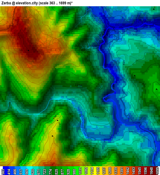
Below is the Elevation map of Zerba, which displays elevation range with different colors. Scale of the first map is from 363 to 1699 m (1191 to 5574 ft) with average elevation of 850.2 meters (=2789 ft) [note 1]
These maps also provides idea of topography and contour of this city, they are displayed at different zoom levels. More info about maps, scale and edge coordinates you can find below images.
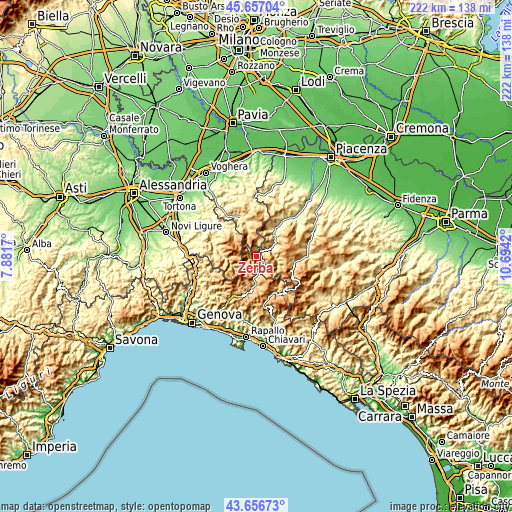
| \ | Map #1 | Topo.Map |
| Scale [m] | 363..1699 m | × |
| Scale [ft] | 1191..5574 ft | × |
| Average | 850.2 m = 2789 ft | × |
| Width | 6.95 km = 4.3 mi | 222.4 km = 138.2 mi |
| Height | 6.95 km = 4.3 mi | 222.4 km = 138.2 mi |
| ↑Max Latitude | 44.696756° | 45.65704° |
| Latitude at center | 44.66551° | 44.66551° |
| ↓Min Latitude | 44.634247° | 43.65673° |
| ← Min Longitude | 9.244005° | 7.8817° |
| Longitude center | 9.28795° | 9.28795° |
| →Max Longitude | 9.331895° | 10.6942° |
Nearby cities:
Cities around Zerba sort by population:
• Santa Margherita di Staffora elevation 548 m
12.4 km,  342°
342°
• Marsaglia 344 m
9.2 km,  55°
55°
• Ottone 495 m
5.9 km,  143°
143°
• Fontanigorda 809 m
13.4 km,  174°
174°
• Coli 644 m
13.4 km,  48°
48°
• Rovegno 665 m
9.9 km,  184°
184°
• Cerignale 711 m
5.2 km,  74°
74°
• Gorreto 528 m
6.7 km, 177°
• Rondanina 987 m
12.6 km,  205°
205°
• Pregola 1015 m
9.5 km,  357°
357°
• Carrega Ligure 942 m
10.3 km,  239°
239°
• Fascia 1113 m
10.6 km, 209°
Multilingual:
 En español:
Zerba elevación 806 m.
 En France:
Zerba élévation 806 m.


Sources and notes:
- [note 1] Map square and city borders are not equal. Map elevation data is calculated only from area inside that square.
- [src 1] Elevation data from geonames database provided with same terms of usage.
- [src 2] The elevation map of Zerba is generated using elevation data from NASA's 3 arcsec (90m) resolution SRTM data.
- [src 3] Base (background) map © OpenStreetMap contributors tiles are generated by Geofabrik and OpenTopoMap.
Copyright & License:
This Zerba Elevation Map is licensed under CC BY-SA. You may reuse any part from this page, if you give a proper credit by linking to this URL:
 More info on terms of use page.