Samone elevation
Samone (Trentino-Alto Adige, Provincia autonoma di Trento), Italy elevation is 690 meters and Samone elevation in feet is 2264 ft above sea level [src 1]. Samone is a seat of a third-order administrative division (feature code) with elevation that is 368 meters (1207 ft) bigger than average city elevation in Italy.
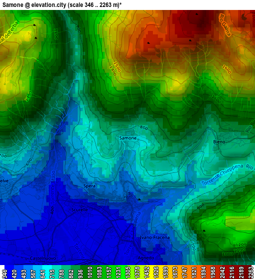
Below is the Elevation map of Samone, which displays elevation range with different colors. Scale of the first map is from 346 to 2263 m (1135 to 7425 ft) with average elevation of 956.3 meters (=3137 ft) [note 1]
These maps also provides idea of topography and contour of this city, they are displayed at different zoom levels. More info about maps, scale and edge coordinates you can find below images.
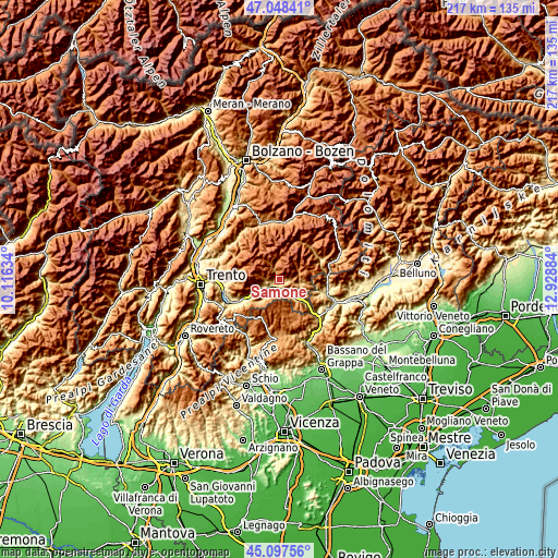
| \ | Map #1 | Topo.Map |
| Scale [m] | 346..2263 m | × |
| Scale [ft] | 1135..7425 ft | × |
| Average | 956.3 m = 3137 ft | × |
| Width | 6.78 km = 4.2 mi | 216.9 km = 134.8 mi |
| Height | 6.78 km = 4.2 mi | 216.9 km = 134.8 mi |
| ↑Max Latitude | 46.112084° | 47.04841° |
| Latitude at center | 46.08161° | 46.08161° |
| ↓Min Latitude | 46.05112° | 45.09756° |
| ← Min Longitude | 11.478645° | 10.11634° |
| Longitude center | 11.52259° | 11.52259° |
| →Max Longitude | 11.566535° | 12.92884° |
Nearby cities:
Cities around Samone sort by population:
• Borgo Valsugana elevation 396 m
6.1 km,  236°
236°
• Telve 531 m
3.5 km,  248°
248°
• Strigno 473 m
1.6 km,  180°
180°
• Scurelle 383 m
2.3 km,  214°
214°
• Villa-Agnedo 383 m
3.1 km,  171°
171°
• Castelnuovo 371 m
4 km,  220°
220°
• Ospedaletto 342 m
5 km,  150°
150°
• Telve di Sopra 647 m
4.1 km, 253°
• Spera 553 m
1.6 km, 219°
• Torcegno 760 m
5.7 km,  261°
261°
• Carzano 440 m
2.5 km, 241°
• Bieno 836 m
2.6 km,  90°
90°
Multilingual:
 En español:
Samone elevación 690 m.
 En France:
Samone élévation 690 m.


Sources and notes:
- [note 1] Map square and city borders are not equal. Map elevation data is calculated only from area inside that square.
- [src 1] Elevation data from geonames database provided with same terms of usage.
- [src 2] The elevation map of Samone is generated using elevation data from NASA's 3 arcsec (90m) resolution SRTM data.
- [src 3] Base (background) map © OpenStreetMap contributors tiles are generated by Geofabrik and OpenTopoMap.
Copyright & License:
This Samone Elevation Map is licensed under CC BY-SA. You may reuse any part from this page, if you give a proper credit by linking to this URL:
 More info on terms of use page.