Grognardo elevation
Grognardo (Piedmont, Provincia di Alessandria), Italy elevation is 216 meters and Grognardo elevation in feet is 709 ft above sea level [src 1]. Grognardo is a seat of a third-order administrative division (feature code) with elevation that is 106 meters (348 ft) smaller than average city elevation in Italy.
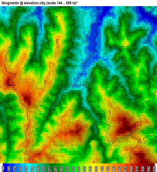
Below is the Elevation map of Grognardo, which displays elevation range with different colors. Scale of the first map is from 144 to 558 m (472 to 1831 ft) with average elevation of 327.1 meters (=1073 ft) [note 1]
These maps also provides idea of topography and contour of this city, they are displayed at different zoom levels. More info about maps, scale and edge coordinates you can find below images.
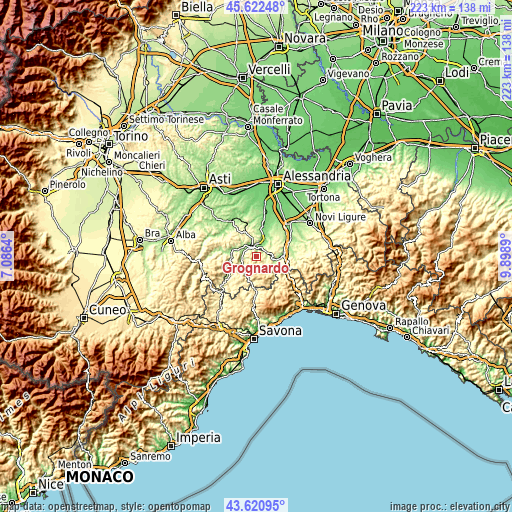
| \ | Map #1 | Topo.Map |
| Scale [m] | 144..558 m | × |
| Scale [ft] | 472..1831 ft | × |
| Average | 327.1 m = 1073 ft | × |
| Width | 6.95 km = 4.3 mi | 222.5 km = 138.3 mi |
| Height | 6.95 km = 4.3 mi | 222.5 km = 138.3 mi |
| ↑Max Latitude | 44.661605° | 45.62248° |
| Latitude at center | 44.63034° | 44.63034° |
| ↓Min Latitude | 44.599058° | 43.62095° |
| ← Min Longitude | 8.448705° | 7.0864° |
| Longitude center | 8.49265° | 8.49265° |
| →Max Longitude | 8.536595° | 9.8989° |
Nearby cities:
Cities around Grognardo sort by population:
• Acqui Terme elevation 161 m
5.4 km,  339°
339°
• Visone 168 m
3.6 km,  10°
10°
• Morbello 398 m
3.2 km,  153°
153°
• Morsasco 311 m
6 km,  49°
49°
• Terzo 212 m
7.2 km,  308°
308°
• Cassinelle-Concentrico 373 m
6.5 km,  119°
119°
• Cartosio 249 m
7.2 km,  231°
231°
• Melazzo 236 m
5.6 km,  285°
285°
• Cremolino 414 m
7.4 km,  84°
84°
• Ponzone 602 m
5.4 km,  209°
209°
• Prasco 244 m
4.8 km, 77°
• Cavatore 512 m
3.2 km,  271°
271°
Multilingual:
 En español:
Grognardo elevación 216 m.
 En France:
Grognardo élévation 216 m.
 Auf Deutsch:
Grognardo höhe über dem Meeresspiegel ist 216 m.

Sources and notes:
- [note 1] Map square and city borders are not equal. Map elevation data is calculated only from area inside that square.
- [src 1] Elevation data from geonames database provided with same terms of usage.
- [src 2] The elevation map of Grognardo is generated using elevation data from NASA's 3 arcsec (90m) resolution SRTM data.
- [src 3] Base (background) map © OpenStreetMap contributors tiles are generated by Geofabrik and OpenTopoMap.
Copyright & License:
This Grognardo Elevation Map is licensed under CC BY-SA. You may reuse any part from this page, if you give a proper credit by linking to this URL:
 More info on terms of use page.