Gremiasco elevation
Gremiasco (Piedmont, Provincia di Alessandria), Italy elevation is 400 meters and Gremiasco elevation in feet is 1312 ft above sea level [src 1]. Gremiasco is a seat of a third-order administrative division (feature code) with elevation that is 78 meters (256 ft) bigger than average city elevation in Italy.
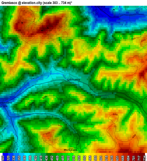
Below is the Elevation map of Gremiasco, which displays elevation range with different colors. Scale of the first map is from 303 to 734 m (994 to 2408 ft) with average elevation of 495.7 meters (=1626 ft) [note 1]
These maps also provides idea of topography and contour of this city, they are displayed at different zoom levels. More info about maps, scale and edge coordinates you can find below images.
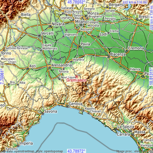
| \ | Map #1 | Topo.Map |
| Scale [m] | 303..734 m | × |
| Scale [ft] | 994..2408 ft | × |
| Average | 495.7 m = 1626 ft | × |
| Width | 6.93 km = 4.3 mi | 221.9 km = 137.9 mi |
| Height | 6.93 km = 4.3 mi | 221.9 km = 137.9 mi |
| ↑Max Latitude | 44.827426° | 45.78552° |
| Latitude at center | 44.79625° | 44.79625° |
| ↓Min Latitude | 44.765057° | 43.78972° |
| ← Min Longitude | 9.062915° | 7.70061° |
| Longitude center | 9.10686° | 9.10686° |
| →Max Longitude | 9.150805° | 10.51311° |
Nearby cities:
Cities around Gremiasco sort by population:
• Varzi elevation 419 m
7.8 km,  67°
67°
• San Sebastiano Curone 330 m
3.5 km,  251°
251°
• Garbagna 291 m
8.8 km,  258°
258°
• Ponte Nizza 266 m
6.2 km,  353°
353°
• Bagnaria 328 m
3.7 km,  19°
19°
• Brignano 283 m
5.7 km,  291°
291°
• Cecima 340 m
6.4 km,  340°
340°
• Dernice 586 m
5.6 km,  233°
233°
• Casasco 369 m
8.7 km, 293°
• Momperone 270 m
7.4 km,  309°
309°
• Garadassi 712 m
6 km,  141°
141°
• Montacuto 542 m
3.3 km,  182°
182°
Multilingual:
 En español:
Gremiasco elevación 400 m.
 En France:
Gremiasco élévation 400 m.
 Auf Deutsch:
Gremiasco höhe über dem Meeresspiegel ist 400 m.

Sources and notes:
- [note 1] Map square and city borders are not equal. Map elevation data is calculated only from area inside that square.
- [src 1] Elevation data from geonames database provided with same terms of usage.
- [src 2] The elevation map of Gremiasco is generated using elevation data from NASA's 3 arcsec (90m) resolution SRTM data.
- [src 3] Base (background) map © OpenStreetMap contributors tiles are generated by Geofabrik and OpenTopoMap.
Copyright & License:
This Gremiasco Elevation Map is licensed under CC BY-SA. You may reuse any part from this page, if you give a proper credit by linking to this URL:
 More info on terms of use page.