Guarene elevation
Guarene (Piedmont, Provincia di Cuneo), Italy elevation is 348 meters and Guarene elevation in feet is 1142 ft above sea level [src 1]. Guarene is a seat of a third-order administrative division (feature code) with elevation that is 26 meters (85 ft) bigger than average city elevation in Italy.
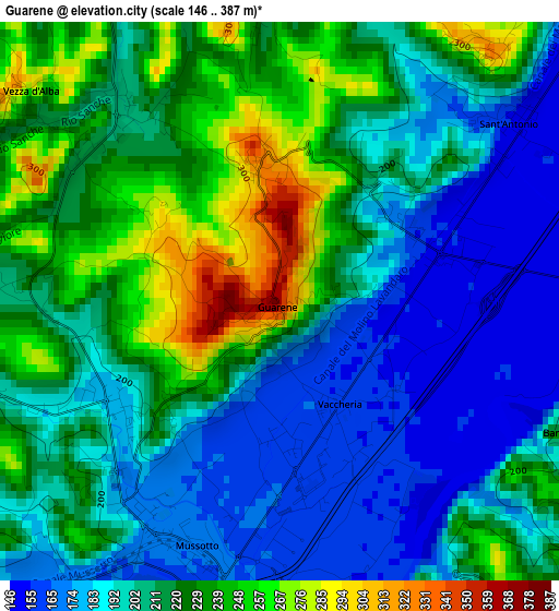
Below is the Elevation map of Guarene, which displays elevation range with different colors. Scale of the first map is from 146 to 387 m (479 to 1270 ft) with average elevation of 209.9 meters (=689 ft) [note 1]
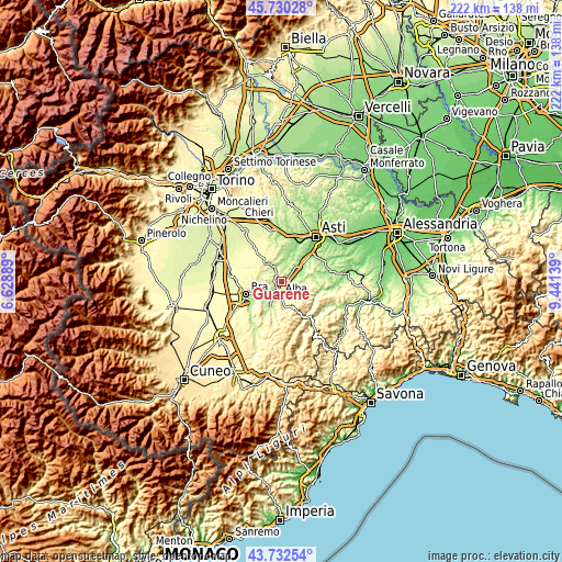
These maps also provides idea of topography and contour of this city, they are displayed at different zoom levels. More info about maps, scale and edge coordinates you can find below images.
| \ | Map #1 | Topo.Map |
| Scale [m] | 146..387 m | × |
| Scale [ft] | 479..1270 ft | × |
| Average | 209.9 m = 689 ft | × |
| Width | 6.94 km = 4.3 mi | 222.1 km = 138 mi |
| Height | 6.94 km = 4.3 mi | 222.1 km = 138 mi |
| ↑Max Latitude | 44.771246° | 45.73028° |
| Latitude at center | 44.74004° | 44.74004° |
| ↓Min Latitude | 44.708817° | 43.73254° |
| ← Min Longitude | 7.991195° | 6.62889° |
| Longitude center | 8.03514° | 8.03514° |
| →Max Longitude | 8.079085° | 9.44139° |
Nearby cities:
Cities around Guarene sort by population:
• Alba elevation 178 m
4.5 km,  180°
180°
• Mussotto 165 m
2.5 km, 181°
• Corneliano d'Alba 209 m
6.2 km,  265°
265°
• Priocca 215 m
5.6 km,  24°
24°
• Vezza d'Alba 204 m
3.3 km,  319°
319°
• Sant'Antonio 156 m
3.5 km,  52°
52°
• Vaccheria 159 m
1.6 km,  156°
156°
• Piobesi d'Alba 197 m
4.4 km,  261°
261°
• Castellinaldo 275 m
3.9 km,  353°
353°
• Castagnito 328 m
1.7 km, 351°
• Magliano Alfieri 287 m
4.3 km,  40°
40°
• Barbaresco 250 m
4.1 km,  116°
116°
Multilingual:
 En español:
Guarene elevación 348 m.
 En France:
Guarene élévation 348 m.


Sources and notes:
- [note 1] Map square and city borders are not equal. Map elevation data is calculated only from area inside that square.
- [src 1] Elevation data from geonames database provided with same terms of usage.
- [src 2] The elevation map of Guarene is generated using elevation data from NASA's 3 arcsec (90m) resolution SRTM data.
- [src 3] Base (background) map © OpenStreetMap contributors tiles are generated by Geofabrik and OpenTopoMap.
Copyright & License:
This Guarene Elevation Map is licensed under CC BY-SA. You may reuse any part from this page, if you give a proper credit by linking to this URL:
 More info on terms of use page.