Frabosa Sottana elevation
Frabosa Sottana (Piedmont, Provincia di Cuneo), Italy elevation is 656 meters and Frabosa Sottana elevation in feet is 2152 ft above sea level [src 1]. Frabosa Sottana is a seat of a third-order administrative division (feature code) with elevation that is 334 meters (1096 ft) bigger than average city elevation in Italy.
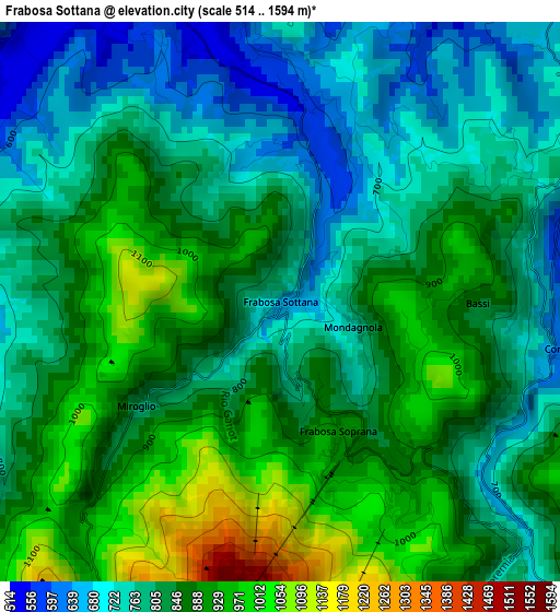
Below is the Elevation map of Frabosa Sottana, which displays elevation range with different colors. Scale of the first map is from 514 to 1594 m (1686 to 5230 ft) with average elevation of 828.5 meters (=2718 ft) [note 1]
These maps also provides idea of topography and contour of this city, they are displayed at different zoom levels. More info about maps, scale and edge coordinates you can find below images.
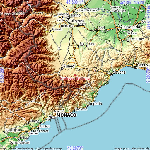
| \ | Map #1 | Topo.Map |
| Scale [m] | 514..1594 m | × |
| Scale [ft] | 1686..5230 ft | × |
| Average | 828.5 m = 2718 ft | × |
| Width | 6.99 km = 4.3 mi | 223.8 km = 139.1 mi |
| Height | 6.99 km = 4.3 mi | 223.8 km = 139.1 mi |
| ↑Max Latitude | 44.333772° | 45.30011° |
| Latitude at center | 44.30233° | 44.30233° |
| ↓Min Latitude | 44.270871° | 43.2873° |
| ← Min Longitude | 7.753595° | 6.39129° |
| Longitude center | 7.79754° | 7.79754° |
| →Max Longitude | 7.841485° | 9.20379° |
Nearby cities:
Cities around Frabosa Sottana sort by population:
• Villanova Mondovì elevation 529 m
5.6 km,  334°
334°
• Chiusa di Pesio 571 m
10.1 km,  284°
284°
• Vicoforte 520 m
8.6 km,  37°
37°
• Piazza 536 m
9.7 km,  16°
16°
• Monastero di Vasco 516 m
4.7 km,  25°
25°
• Roccaforte Mondovì 577 m
4.6 km,  291°
291°
• Torre Mondovì 465 m
9.9 km,  55°
55°
• Frabosa Soprana 861 m
1.4 km,  159°
159°
• Roapiana 527 m
4.7 km, 25°
• Pamparato 800 m
9.7 km,  107°
107°
• Roburent 810 m
7.5 km,  86°
86°
• Montaldo di Mondovì 785 m
5.9 km,  68°
68°
Multilingual:
 En español:
Frabosa Sottana elevación 656 m.
 En France:
Frabosa Sottana élévation 656 m.
 Auf Deutsch:
Frabosa Sottana höhe über dem Meeresspiegel ist 656 m.

Sources and notes:
- [note 1] Map square and city borders are not equal. Map elevation data is calculated only from area inside that square.
- [src 1] Elevation data from geonames database provided with same terms of usage.
- [src 2] The elevation map of Frabosa Sottana is generated using elevation data from NASA's 3 arcsec (90m) resolution SRTM data.
- [src 3] Base (background) map © OpenStreetMap contributors tiles are generated by Geofabrik and OpenTopoMap.
Copyright & License:
This Frabosa Sottana Elevation Map is licensed under CC BY-SA. You may reuse any part from this page, if you give a proper credit by linking to this URL:
 More info on terms of use page.