Clavesana elevation
Clavesana (Piedmont, Provincia di Cuneo), Italy elevation is 291 meters and Clavesana elevation in feet is 955 ft above sea level [src 1]. Clavesana is a seat of a third-order administrative division (feature code) with elevation that is 31 meters (102 ft) smaller than average city elevation in Italy.
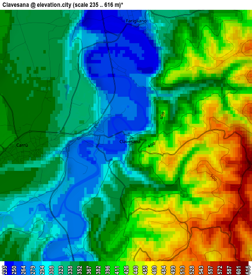
Below is the Elevation map of Clavesana, which displays elevation range with different colors. Scale of the first map is from 235 to 616 m (771 to 2021 ft) with average elevation of 372.5 meters (=1222 ft) [note 1]
These maps also provides idea of topography and contour of this city, they are displayed at different zoom levels. More info about maps, scale and edge coordinates you can find below images.
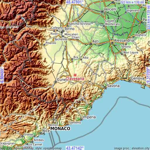
| \ | Map #1 | Topo.Map |
| Scale [m] | 235..616 m | × |
| Scale [ft] | 771..2021 ft | × |
| Average | 372.5 m = 1222 ft | × |
| Width | 6.97 km = 4.3 mi | 223.1 km = 138.6 mi |
| Height | 6.97 km = 4.3 mi | 223.1 km = 138.6 mi |
| ↑Max Latitude | 44.514685° | 45.47801° |
| Latitude at center | 44.48334° | 44.48334° |
| ↓Min Latitude | 44.451979° | 43.47142° |
| ← Min Longitude | 7.866895° | 6.50459° |
| Longitude center | 7.91084° | 7.91084° |
| →Max Longitude | 7.954785° | 9.31709° |
Nearby cities:
Cities around Clavesana sort by population:
• Dogliani elevation 289 m
6.2 km,  26°
26°
• Carrù 363 m
3.1 km,  262°
262°
• Magliano Alpi 382 m
7.8 km,  248°
248°
• Farigliano 265 m
3.2 km,  4°
4°
• Murazzano 727 m
8.7 km,  97°
97°
• Piozzo 329 m
3.7 km,  336°
336°
• Bastia Mondovì 297 m
4.8 km,  195°
195°
• Belvedere Langhe 641 m
5.1 km,  77°
77°
• Marsaglia 597 m
6.4 km,  121°
121°
• Rocca Cigliè 590 m
5.3 km,  143°
143°
• Cigliè 535 m
5.4 km,  166°
166°
• Castellino Tanaro 599 m
8.3 km, 137°
Multilingual:
 En español:
Clavesana elevación 291 m.
 En France:
Clavesana élévation 291 m.
 Auf Deutsch:
Clavesana höhe über dem Meeresspiegel ist 291 m.

Sources and notes:
- [note 1] Map square and city borders are not equal. Map elevation data is calculated only from area inside that square.
- [src 1] Elevation data from geonames database provided with same terms of usage.
- [src 2] The elevation map of Clavesana is generated using elevation data from NASA's 3 arcsec (90m) resolution SRTM data.
- [src 3] Base (background) map © OpenStreetMap contributors tiles are generated by Geofabrik and OpenTopoMap.
Copyright & License:
This Clavesana Elevation Map is licensed under CC BY-SA. You may reuse any part from this page, if you give a proper credit by linking to this URL:
 More info on terms of use page.