Cureggio elevation
Cureggio (Piedmont, Provincia di Novara), Italy elevation is 293 meters and Cureggio elevation in feet is 961 ft above sea level [src 1]. Cureggio is a seat of a third-order administrative division (feature code) with elevation that is 29 meters (95 ft) smaller than average city elevation in Italy.
Below is the Elevation map of Cureggio, which displays elevation range with different colors. Scale of the first map is from 260 to 433 m (853 to 1421 ft) with average elevation of 318.1 meters (=1044 ft) [note 1]
These maps also provides idea of topography and contour of this city, they are displayed at different zoom levels. More info about maps, scale and edge coordinates you can find below images.
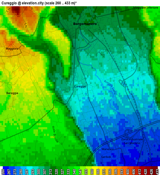
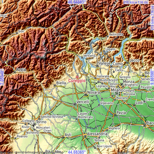
| \ | Map #1 | Topo.Map |
| Scale [m] | 260..433 m | × |
| Scale [ft] | 853..1421 ft | × |
| Average | 318.1 m = 1044 ft | × |
| Width | 6.83 km = 4.2 mi | 218.5 km = 135.8 mi |
| Height | 6.83 km = 4.2 mi | 218.5 km = 135.8 mi |
| ↑Max Latitude | 45.705567° | 46.64883° |
| Latitude at center | 45.67487° | 45.67487° |
| ↓Min Latitude | 45.644156° | 44.68365° |
| ← Min Longitude | 8.415785° | 7.05348° |
| Longitude center | 8.45973° | 8.45973° |
| →Max Longitude | 8.503675° | 9.86598° |
Nearby cities:
Cities around Cureggio sort by population:
• Borgomanero elevation 315 m
2.7 km,  4°
4°
• Briga Novarese 336 m
6.1 km,  357°
357°
• Gattico 386 m
5.9 km,  52°
52°
• Gargallo 402 m
6.6 km,  335°
335°
• Maggiora 382 m
3.3 km,  299°
299°
• Cavaglio D'Agogna 245 m
7.2 km,  163°
163°
• Fontaneto D'Agogna 265 m
3.8 km, 157°
• Cavallirio 363 m
5.1 km,  253°
253°
• Veruno 351 m
5.6 km,  73°
73°
• Bogogno 283 m
6 km,  102°
102°
• Boca 392 m
4 km,  276°
276°
• Cressa 270 m
4.9 km,  128°
128°
Multilingual:
 En español:
Cureggio elevación 293 m.
 En France:
Cureggio élévation 293 m.
 Auf Deutsch:
Cureggio höhe über dem Meeresspiegel ist 293 m.

Sources and notes:
- [note 1] Map square and city borders are not equal. Map elevation data is calculated only from area inside that square.
- [src 1] Elevation data from geonames database provided with same terms of usage.
- [src 2] The elevation map of Cureggio is generated using elevation data from NASA's 3 arcsec (90m) resolution SRTM data.
- [src 3] Base (background) map © OpenStreetMap contributors tiles are generated by Geofabrik and OpenTopoMap.
Copyright & License:
This Cureggio Elevation Map is licensed under CC BY-SA. You may reuse any part from this page, if you give a proper credit by linking to this URL:
 More info on terms of use page.