Amato elevation
Amato (Calabria, Provincia di Catanzaro), Italy elevation is 446 meters and Amato elevation in feet is 1463 ft above sea level [src 1]. Amato is a seat of a third-order administrative division (feature code) with elevation that is 124 meters (407 ft) bigger than average city elevation in Italy.
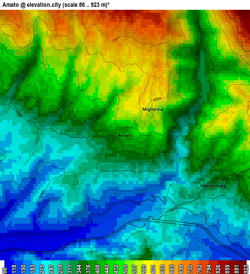
Below is the Elevation map of Amato, which displays elevation range with different colors. Scale of the first map is from 86 to 923 m (282 to 3028 ft) with average elevation of 378.5 meters (=1242 ft) [note 1]
These maps also provides idea of topography and contour of this city, they are displayed at different zoom levels. More info about maps, scale and edge coordinates you can find below images.
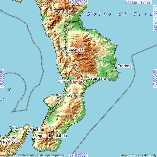
| \ | Map #1 | Topo.Map |
| Scale [m] | 86..923 m | × |
| Scale [ft] | 282..3028 ft | × |
| Average | 378.5 m = 1242 ft | × |
| Width | 7.6 km = 4.7 mi | 243.2 km = 151.1 mi |
| Height | 7.6 km = 4.7 mi | 243.2 km = 151.1 mi |
| ↑Max Latitude | 38.975962° | 40.02709° |
| Latitude at center | 38.94179° | 38.94179° |
| ↓Min Latitude | 38.907602° | 37.83962° |
| ← Min Longitude | 16.418255° | 15.05595° |
| Longitude center | 16.4622° | 16.4622° |
| →Max Longitude | 16.506145° | 17.86845° |
Nearby cities:
Cities around Amato sort by population:
• Gimigliano elevation 530 m
7 km,  59°
59°
• Tiriolo 619 m
4.2 km,  91°
91°
• Pianopoli 239 m
6.5 km,  280°
280°
• Marcellinara 306 m
2.8 km,  129°
129°
• San Pietro Apostolo 767 m
6.9 km,  4°
4°
• Caraffa di Catanzaro 360 m
7 km,  162°
162°
• Sant'Elia 647 m
10.8 km,  80°
80°
• Settingiano 245 m
5.6 km, 127°
• Cicala 858 m
9.2 km,  13°
13°
• Serrastretta 836 m
8.9 km,  333°
333°
• Miglierina 580 m
1.3 km,  41°
41°
• Feroleto Antico 299 m
6.8 km,  289°
289°
Multilingual:
 En español:
Amato elevación 446 m.
 En France:
Amato élévation 446 m.


Sources and notes:
- [note 1] Map square and city borders are not equal. Map elevation data is calculated only from area inside that square.
- [src 1] Elevation data from geonames database provided with same terms of usage.
- [src 2] The elevation map of Amato is generated using elevation data from NASA's 3 arcsec (90m) resolution SRTM data.
- [src 3] Base (background) map © OpenStreetMap contributors tiles are generated by Geofabrik and OpenTopoMap.
Copyright & License:
This Amato Elevation Map is licensed under CC BY-SA. You may reuse any part from this page, if you give a proper credit by linking to this URL:
 More info on terms of use page.