Sperone elevation
Sperone (Campania, Provincia di Avellino), Italy elevation is 177 meters and Sperone elevation in feet is 581 ft above sea level [src 1]. Sperone is a seat of a third-order administrative division (feature code) with elevation that is 145 meters (476 ft) smaller than average city elevation in Italy.
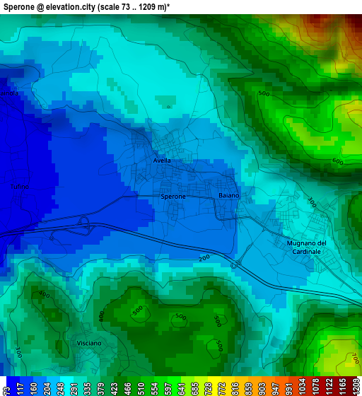
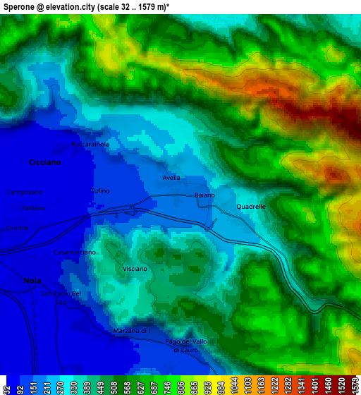
Below is the Elevation map of Sperone, which displays elevation range with different colors. Scale of the first map is from 73 to 1209 m (240 to 3967 ft) with average elevation of 325.9 meters (=1069 ft) [note 1]
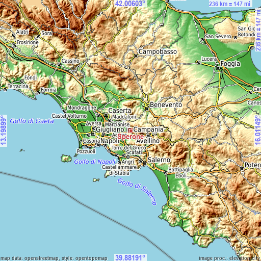
These maps also provides idea of topography and contour of this city, they are displayed at different zoom levels. More info about maps, scale and edge coordinates you can find below images.
| \ | Map #1 | Map #2 | Topo.Map |
| Scale [m] | 73..1209 m | 32..1579 m | × |
| Scale [ft] | 240..3967 ft | 105..5180 ft | × |
| Average | 325.9 m = 1069 ft | 459.5 m = 1508 ft | × |
| Width | 7.38 km = 4.6 mi | 14.76 km = 9.2 mi | 236.2 km = 146.8 mi |
| Height | 7.38 km = 4.6 mi | 14.76 km = 9.2 mi | 236.2 km = 146.8 mi |
| ↑Max Latitude | 40.985691° | 41.018856° | 42.00603° |
| Latitude at center | 40.95251° | 40.95251° | 40.95251° |
| ↓Min Latitude | 40.919312° | 40.886097° | 39.88191° |
| ← Min Longitude | 14.561295° | 14.517349° | 13.19899° |
| Longitude center | 14.60524° | 14.60524° | 14.60524° |
| →Max Longitude | 14.649185° | 14.693131° | 16.01149° |
Nearby cities:
Cities around Sperone sort by population:
• Cicciano elevation 50 m
6 km,  282°
282°
• Avella 206 m
0.9 km,  336°
336°
• Roccarainola 76 m
5.7 km,  292°
292°
• Mugnano del Cardinale 253 m
2.8 km,  113°
113°
• Baiano 195 m
1 km,  97°
97°
• Visciano 337 m
3.7 km,  211°
211°
• Casamarciano 73 m
4.9 km,  242°
242°
• Sirignano 253 m
2 km, 98°
• Tufino 97 m
3.3 km, 276°
• Quadrelle 293 m
2.9 km, 98°
• Marzano di Nola 110 m
6 km,  197°
197°
• Comiziano 74 m
4.5 km,  268°
268°
Multilingual:
 En español:
Sperone elevación 177 m.
 En France:
Sperone élévation 177 m.


Sources and notes:
- [note 1] Map square and city borders are not equal. Map elevation data is calculated only from area inside that square.
- [src 1] Elevation data from geonames database provided with same terms of usage.
- [src 2] The elevation map of Sperone is generated using elevation data from NASA's 3 arcsec (90m) resolution SRTM data.
- [src 3] Base (background) map © OpenStreetMap contributors tiles are generated by Geofabrik and OpenTopoMap.
Copyright & License:
This Sperone Elevation Map is licensed under CC BY-SA. You may reuse any part from this page, if you give a proper credit by linking to this URL:
 More info on terms of use page.