Pietraroja elevation
Pietraroja (Campania, Provincia di Benevento), Italy elevation is 816 meters and Pietraroja elevation in feet is 2677 ft above sea level [src 1]. Pietraroja is a seat of a third-order administrative division (feature code) with elevation that is 494 meters (1621 ft) bigger than average city elevation in Italy.
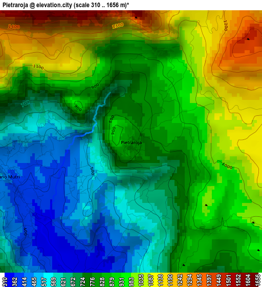
Below is the Elevation map of Pietraroja, which displays elevation range with different colors. Scale of the first map is from 310 to 1656 m (1017 to 5433 ft) with average elevation of 819.4 meters (=2688 ft) [note 1]
These maps also provides idea of topography and contour of this city, they are displayed at different zoom levels. More info about maps, scale and edge coordinates you can find below images.
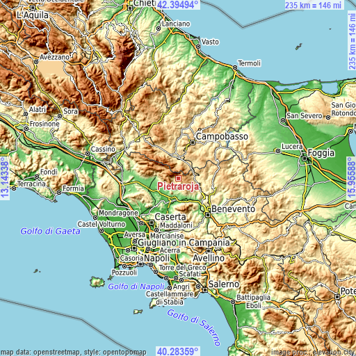
| \ | Map #1 | Topo.Map |
| Scale [m] | 310..1656 m | × |
| Scale [ft] | 1017..5433 ft | × |
| Average | 819.4 m = 2688 ft | × |
| Width | 7.34 km = 4.6 mi | 234.8 km = 145.9 mi |
| Height | 7.34 km = 4.6 mi | 234.8 km = 145.9 mi |
| ↑Max Latitude | 41.380802° | 42.39494° |
| Latitude at center | 41.34782° | 41.34782° |
| ↓Min Latitude | 41.314821° | 40.28359° |
| ← Min Longitude | 14.505685° | 13.14338° |
| Longitude center | 14.54963° | 14.54963° |
| →Max Longitude | 14.593575° | 15.95588° |
Nearby cities:
Cities around Pietraroja sort by population:
• Guardia Sanframondi elevation 443 m
11 km,  158°
158°
• Cerreto Sannita 278 m
7.3 km,  172°
172°
• Morcone 462 m
10 km,  93°
93°
• Cusano Mutri 394 m
3.5 km,  248°
248°
• Sepino 703 m
8.9 km,  41°
41°
• Gioia Sannitica 251 m
10.3 km,  238°
238°
• San Lorenzello 213 m
8 km,  184°
184°
• Faicchio 180 m
9.8 km,  217°
217°
• San Lupo 495 m
12 km,  143°
143°
• Campochiaro 669 m
11.7 km,  342°
342°
• Guardiaregia 715 m
9.6 km,  356°
356°
• Sassinoro 542 m
10 km,  72°
72°
Multilingual:
 En español:
Pietraroja elevación 816 m.
 En France:
Pietraroja élévation 816 m.
 Auf Deutsch:
Pietraroja höhe über dem Meeresspiegel ist 816 m.

Sources and notes:
- [note 1] Map square and city borders are not equal. Map elevation data is calculated only from area inside that square.
- [src 1] Elevation data from geonames database provided with same terms of usage.
- [src 2] The elevation map of Pietraroja is generated using elevation data from NASA's 3 arcsec (90m) resolution SRTM data.
- [src 3] Base (background) map © OpenStreetMap contributors tiles are generated by Geofabrik and OpenTopoMap.
Copyright & License:
This Pietraroja Elevation Map is licensed under CC BY-SA. You may reuse any part from this page, if you give a proper credit by linking to this URL:
 More info on terms of use page.