Casaletto di Sopra elevation
Casaletto di Sopra (Lombardy, Provincia di Cremona), Italy elevation is 88 meters and Casaletto di Sopra elevation in feet is 289 ft above sea level [src 1]. Casaletto di Sopra is a seat of a third-order administrative division (feature code) with elevation that is 234 meters (768 ft) smaller than average city elevation in Italy.
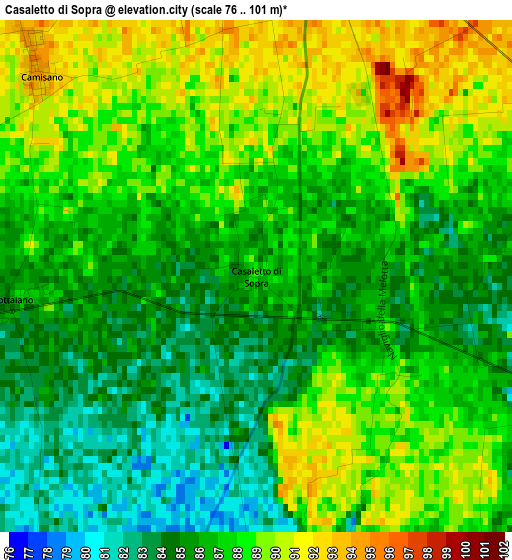
Below is the Elevation map of Casaletto di Sopra, which displays elevation range with different colors. Scale of the first map is from 76 to 101 m (249 to 331 ft) with average elevation of 86.8 meters (=285 ft) [note 1]
These maps also provides idea of topography and contour of this city, they are displayed at different zoom levels. More info about maps, scale and edge coordinates you can find below images.
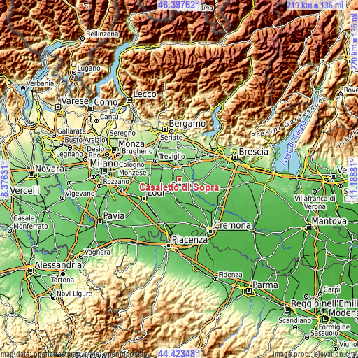
| \ | Map #1 | Topo.Map |
| Scale [m] | 76..101 m | × |
| Scale [ft] | 249..331 ft | × |
| Average | 86.8 m = 285 ft | × |
| Width | 6.86 km = 4.3 mi | 219.5 km = 136.4 mi |
| Height | 6.86 km = 4.3 mi | 219.5 km = 136.4 mi |
| ↑Max Latitude | 45.450017° | 46.39762° |
| Latitude at center | 45.41918° | 45.41918° |
| ↓Min Latitude | 45.388326° | 44.42348° |
| ← Min Longitude | 9.738615° | 8.37631° |
| Longitude center | 9.78256° | 9.78256° |
| →Max Longitude | 9.826505° | 11.18881° |
Nearby cities:
Cities around Casaletto di Sopra sort by population:
• Offanengo elevation 82 m
5.5 km,  215°
215°
• Soncino 81 m
7 km,  107°
107°
• Fontanella 105 m
5.8 km,  15°
15°
• Sergnano 89 m
6.4 km,  278°
278°
• Romanengo 81 m
4.6 km,  174°
174°
• Casale Cremasco 90 m
5.5 km, 284°
• Camisano 94 m
4.1 km,  314°
314°
• Salvirola 73 m
7 km,  182°
182°
• Ricengo 84 m
4.8 km,  251°
251°
• Barbata 103 m
6.2 km,  356°
356°
• Ticengo 78 m
6.6 km,  147°
147°
• Isso 102 m
6.7 km,  343°
343°
Multilingual:
 En español:
Casaletto di Sopra elevación 88 m.
 En France:
Casaletto di Sopra élévation 88 m.
 Auf Deutsch:
Casaletto di Sopra höhe über dem Meeresspiegel ist 88 m.

Sources and notes:
- [note 1] Map square and city borders are not equal. Map elevation data is calculated only from area inside that square.
- [src 1] Elevation data from geonames database provided with same terms of usage.
- [src 2] The elevation map of Casaletto di Sopra is generated using elevation data from NASA's 3 arcsec (90m) resolution SRTM data.
- [src 3] Base (background) map © OpenStreetMap contributors tiles are generated by Geofabrik and OpenTopoMap.
Copyright & License:
This Casaletto di Sopra Elevation Map is licensed under CC BY-SA. You may reuse any part from this page, if you give a proper credit by linking to this URL:
 More info on terms of use page.