Trivolzio elevation
Trivolzio (Lombardy, Provincia di Pavia), Italy elevation is 93 meters and Trivolzio elevation in feet is 305 ft above sea level [src 1]. Trivolzio is a seat of a third-order administrative division (feature code) with elevation that is 229 meters (751 ft) smaller than average city elevation in Italy.
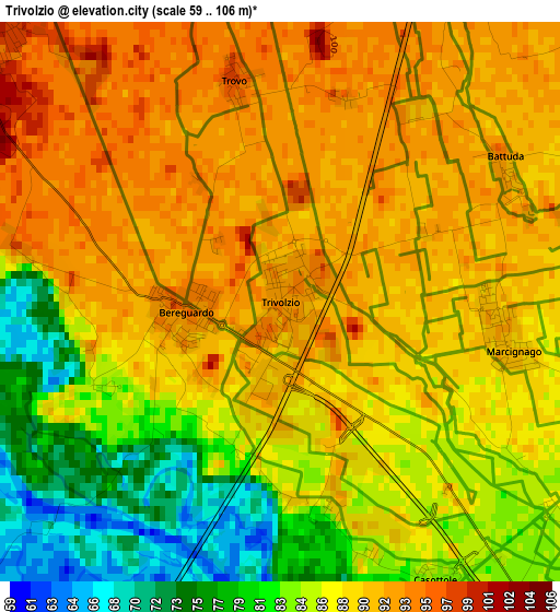
Below is the Elevation map of Trivolzio, which displays elevation range with different colors. Scale of the first map is from 59 to 106 m (194 to 348 ft) with average elevation of 87.5 meters (=287 ft) [note 1]
These maps also provides idea of topography and contour of this city, they are displayed at different zoom levels. More info about maps, scale and edge coordinates you can find below images.
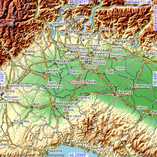
| \ | Map #1 | Topo.Map |
| Scale [m] | 59..106 m | × |
| Scale [ft] | 194..348 ft | × |
| Average | 87.5 m = 287 ft | × |
| Width | 6.88 km = 4.3 mi | 220.1 km = 136.8 mi |
| Height | 6.88 km = 4.3 mi | 220.1 km = 136.8 mi |
| ↑Max Latitude | 45.289385° | 46.23971° |
| Latitude at center | 45.25846° | 45.25846° |
| ↓Min Latitude | 45.227518° | 44.25996° |
| ← Min Longitude | 8.998805° | 7.6365° |
| Longitude center | 9.04275° | 9.04275° |
| →Max Longitude | 9.086695° | 10.449° |
Nearby cities:
Cities around Trivolzio sort by population:
• Casorate Primo elevation 99 m
6.2 km,  341°
341°
• Motta Visconti 100 m
5.1 km,  309°
309°
• Bereguardo 95 m
1.2 km,  262°
262°
• Marcignago 89 m
2.9 km,  101°
101°
• Vellezzo Bellini 91 m
4.7 km,  74°
74°
• Moncucco 101 m
5.8 km,  357°
357°
• Giovenzano 92 m
6 km, 74°
• Trovo 96 m
2.8 km,  348°
348°
• Zerbolò 69 m
6.2 km,  201°
201°
• Rognano 93 m
5 km,  48°
48°
• Battuda 92 m
3.3 km,  56°
56°
• Torre d'Isola 86 m
5.2 km,  149°
149°
Multilingual:
 En español:
Trivolzio elevación 93 m.
 En France:
Trivolzio élévation 93 m.
 Auf Deutsch:
Trivolzio höhe über dem Meeresspiegel ist 93 m.

Sources and notes:
- [note 1] Map square and city borders are not equal. Map elevation data is calculated only from area inside that square.
- [src 1] Elevation data from geonames database provided with same terms of usage.
- [src 2] The elevation map of Trivolzio is generated using elevation data from NASA's 3 arcsec (90m) resolution SRTM data.
- [src 3] Base (background) map © OpenStreetMap contributors tiles are generated by Geofabrik and OpenTopoMap.
Copyright & License:
This Trivolzio Elevation Map is licensed under CC BY-SA. You may reuse any part from this page, if you give a proper credit by linking to this URL:
 More info on terms of use page.