Magreglio elevation
Magreglio (Lombardy, Provincia di Como), Italy elevation is 749 meters and Magreglio elevation in feet is 2457 ft above sea level [src 1]. Magreglio is a seat of a third-order administrative division (feature code) with elevation that is 427 meters (1401 ft) bigger than average city elevation in Italy.
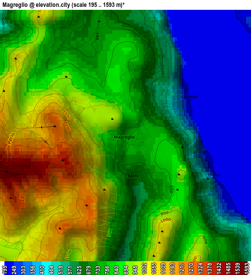
Below is the Elevation map of Magreglio, which displays elevation range with different colors. Scale of the first map is from 195 to 1593 m (640 to 5226 ft) with average elevation of 756.6 meters (=2482 ft) [note 1]
These maps also provides idea of topography and contour of this city, they are displayed at different zoom levels. More info about maps, scale and edge coordinates you can find below images.
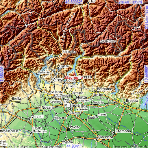
| \ | Map #1 | Topo.Map |
| Scale [m] | 195..1593 m | × |
| Scale [ft] | 640..5226 ft | × |
| Average | 756.6 m = 2482 ft | × |
| Width | 6.8 km = 4.2 mi | 217.5 km = 135.1 mi |
| Height | 6.8 km = 4.2 mi | 217.5 km = 135.1 mi |
| ↑Max Latitude | 45.951542° | 46.89062° |
| Latitude at center | 45.92098° | 45.92098° |
| ↓Min Latitude | 45.890401° | 44.9341° |
| ← Min Longitude | 9.218695° | 7.85639° |
| Longitude center | 9.26264° | 9.26264° |
| →Max Longitude | 9.306585° | 10.66889° |
Nearby cities:
Cities around Magreglio sort by population:
• Mandello del Lario elevation 237 m
4.4 km,  88°
88°
• Abbadia Lariana 233 m
6.1 km,  113°
113°
• Osigo 494 m
5.7 km,  153°
153°
• Valbrona 485 m
5.6 km, 149°
• Lierna 251 m
5.3 km,  38°
38°
• Sormano 778 m
4.9 km,  195°
195°
• Barni 635 m
1.1 km,  166°
166°
• Lasnigo 558 m
4.3 km,  176°
176°
• Caglio 794 m
5.8 km, 199°
• Vassena 213 m
1.9 km,  58°
58°
• Rezzago 669 m
6.1 km,  190°
190°
• Veleso 845 m
6.5 km,  257°
257°
Multilingual:
 En español:
Magreglio elevación 749 m.
 En France:
Magreglio élévation 749 m.
 Auf Deutsch:
Magreglio höhe über dem Meeresspiegel ist 749 m.

Sources and notes:
- [note 1] Map square and city borders are not equal. Map elevation data is calculated only from area inside that square.
- [src 1] Elevation data from geonames database provided with same terms of usage.
- [src 2] The elevation map of Magreglio is generated using elevation data from NASA's 3 arcsec (90m) resolution SRTM data.
- [src 3] Base (background) map © OpenStreetMap contributors tiles are generated by Geofabrik and OpenTopoMap.
Copyright & License:
This Magreglio Elevation Map is licensed under CC BY-SA. You may reuse any part from this page, if you give a proper credit by linking to this URL:
 More info on terms of use page.