Longone al Segrino elevation
Longone al Segrino (Lombardy, Provincia di Como), Italy elevation is 368 meters and Longone al Segrino elevation in feet is 1207 ft above sea level [src 1]. Longone al Segrino is a seat of a third-order administrative division (feature code) with elevation that is 46 meters (151 ft) bigger than average city elevation in Italy.
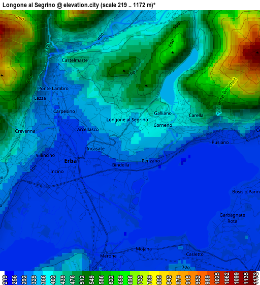
Below is the Elevation map of Longone al Segrino, which displays elevation range with different colors. Scale of the first map is from 219 to 1172 m (719 to 3845 ft) with average elevation of 387.3 meters (=1271 ft) [note 1]
These maps also provides idea of topography and contour of this city, they are displayed at different zoom levels. More info about maps, scale and edge coordinates you can find below images.
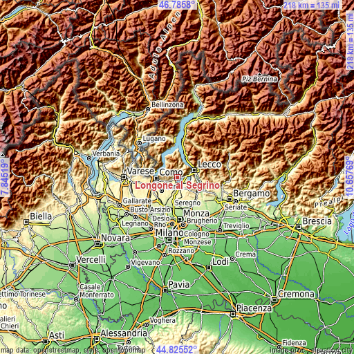
| \ | Map #1 | Topo.Map |
| Scale [m] | 219..1172 m | × |
| Scale [ft] | 719..3845 ft | × |
| Average | 387.3 m = 1271 ft | × |
| Width | 6.81 km = 4.2 mi | 218 km = 135.5 mi |
| Height | 6.81 km = 4.2 mi | 218 km = 135.5 mi |
| ↑Max Latitude | 45.844901° | 46.7858° |
| Latitude at center | 45.81428° | 45.81428° |
| ↓Min Latitude | 45.783642° | 44.82552° |
| ← Min Longitude | 9.207495° | 7.84519° |
| Longitude center | 9.25144° | 9.25144° |
| →Max Longitude | 9.295385° | 10.65769° |
Nearby cities:
Cities around Longone al Segrino sort by population:
• Erba elevation 281 m
2.1 km,  252°
252°
• Canzo 393 m
4.1 km,  21°
21°
• Ponte Lambro 299 m
2.4 km,  300°
300°
• Merone 264 m
3.1 km,  190°
190°
• Bosisio Parini 273 m
3.3 km,  116°
116°
• Rogeno 294 m
4 km,  153°
153°
• Cesana Brianza 283 m
3.7 km,  85°
85°
• Corneno-Galliano-Carella Mariaga 357 m
1.2 km,  77°
77°
• Caslino d'Erba 422 m
3.4 km,  323°
323°
• Pusiano 278 m
2.4 km, 88°
• Castelmarte 455 m
2.5 km, 324°
• Proserpio 469 m
1.6 km,  343°
343°
Multilingual:
 En español:
Longone al Segrino elevación 368 m.
 En France:
Longone al Segrino élévation 368 m.
 Auf Deutsch:
Longone al Segrino höhe über dem Meeresspiegel ist 368 m.
 На русском:
Longone al Segrino высота над уровнем моря 368 м
Sources and notes:
- [note 1] Map square and city borders are not equal. Map elevation data is calculated only from area inside that square.
- [src 1] Elevation data from geonames database provided with same terms of usage.
- [src 2] The elevation map of Longone al Segrino is generated using elevation data from NASA's 3 arcsec (90m) resolution SRTM data.
- [src 3] Base (background) map © OpenStreetMap contributors tiles are generated by Geofabrik and OpenTopoMap.
Copyright & License:
This Longone al Segrino Elevation Map is licensed under CC BY-SA. You may reuse any part from this page, if you give a proper credit by linking to this URL:
 More info on terms of use page.